Route Editor

| Guide | ♦ | 6 Triplogs | 1 Topic |
details | drive | permit | forecast | route |
stats |
photos | triplogs | topic | location |
| 103 | 6 | 1 |
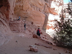
Day hike introduction to Grand Gulch by PaleoRob  The trail starts out at the Kane Gulch Ranger Station, on the east side of Utah Route 261, just a few miles south of Utah Route 95. Here you can pick up a map, get information, fill your water bottles, and pick up your permit. The trail crosses the highway (watch for cars), and from then until you return to your vehicle, you're on the dirt.
The trail drops sharply here and performs a few switchbacks as it bypasses a few medium-sized pourovers. The trail is wells marked and sticks to the northern side of the canyon, so you shouldn't have any trouble here. Then the last and largest pourover comes. This large pourover broaches the entire canyon. The trail winds down to the slickrock next to the pourover. Watch the cairns carefully here, as they generally lead towards the easiest way down the steeper sections of slickrock. Then you're at the level of the top of the pourover. During the winter, and even into the early spring there can often be a ice fall here. Often there is a waterfall year round, though usually not very much flow unless it is after a monsoon storm. The trail crosses the stream, which you can usually accomplish without getting your feet wet, and proceeds down to the new canyon bottom on the south side of the canyon. In this section of steep cutting, where Kane Gulch becomes more of a real canyon, is where Anasazi remains become more prevalent. Keep your eyes peeled for granaries, dwellings, and rock art perched high in alcoves starting in this section. Once you reach the bottom of the canyon again, after passing the pourover, the going becomes easier again. You meander back and forth across the stream bed as the canyon grows higher, bends, and turns. The stream here often performs a disappearing act as it disappears into the sand, only to reappear a few hundred yards away. As you head downstream and west, you'll notice what appears to be an arch on the northern canyon rim. This is actually a series of two close-set hoodoos that mark The Junction. Passing the hoodoos, you'll see a canyon coming in from the north; Grand Gulch proper. If you are backpacking, the cottonwood grove just up Grand Gulch makes an excellent campsite. In addition there is usually water to be found at a small spring just up Grand Gulch as well. Junction Ruin, a popular day hike destination, is only a couple hundred yards upstream in Grand Gulch from The Junction, and the lower levels are easily accessible. If you are wanting to stretch your trip out a bit more, maybe get away from other day hikers, it is possible to hike down Grand Gulch to Turkey Pen ruins and Stimper Arch, making the whole round-trip about 10 miles. Determined hikers can probably day hike to Todie Canyon and back, bringing the total to 14, but you won't get to explore and see much going that speed. Grand Gulch doesn't reveal itself to those in a hurry. Once you've seen all you can see for the time being, return to your vehicle the way you came, back up Kane Gulch. Remember to budget more time for the return trip to deal with the pour-overs and switch backs. Gate Policy: If a gate is closed upon arrival, leave it closed after you go through. If it is open, leave it open. Leaving a closed gate open may put cattle in danger. Closing an open gate may cut them off from water. Please be respectful, leave gates as found. The exception is signage on the gate directing you otherwise. Check out the Official Route and Triplogs. Leave No Trace and +Add a Triplog after your hike to support this local community. | ||||||||||||||||||||||||||||||||||||||||||||||||||||||||||||||||||||||||||||||||||||||||