 Route Editor

| Guide | ♦ | 19 Triplogs | 0 Topics |
details | drive | no permit | forecast | 🔥 route |
stats |
photos | triplogs | topics | location |
| 323 | 19 | 0 |
Canyons are inherently risky. Flash floods occur without notice on sunny days. Technical skills & surrounding topography knowledge required yet does not eliminate risk.
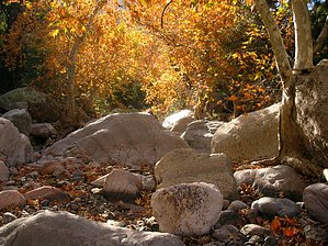
when a stroll in a park just won't do by nonot   Overview OverviewRough Canyon is a rugged, boulder-strewn canyon in the heart of the Superstitions. This trip description covers the approach and descent from Rough Canyon, including the loop back to the starting point of Plow Saddle Springs. Reaching Plow Saddle Springs involves an easy 7-mile jaunt on the northern half of Reavis 109 and a short descent down the Plow Saddle Trail. Reaching this location will take you several hours of hiking and will make a good base camp for your attempt at Rough Canyon. Including the mileage to and from the trailhead, this is best done as a 3 (half, full, half) day loop covering approximately 23 miles. The middle day involving the ascent and descent of the canyon and the hike back to camp is about 9 miles and will take the entire day. As of November 2008, this canyon has no obstacles that require a class 2 canyoneering rating. However, this could change with the next flash flood, so the adventurer should be prepared for the worst.
This is a physically difficult route, there is no easy way to the head of Rough Canyon and it is both a punishing approach and descent. Beginning hikers and canyoneers should cut their teeth on easier routes. Hikers should be skilled in bouldering, bushwhacking, down-climbing, and perhaps pants sewing (:D). Any group that attempts to do this canyon needs to be self-reliant as it is virtually guaranteed that no soul will be coming along within several weeks or years. This is not a route for kids, only bring responsible adults. History Rough Canyon is not suitable for cattle or horses, so it does not have much modern history. The respected historian Tom Kollenborn wrote of ruins found in Rough Canyon several decades ago, but the location of these fabled remnants is not known. The attraction of making a new discovery has encouraged some hikers to explore this canyon. Unfortunately, the most recent events surrounding this canyon were painful. In 2007, an Apache Junction school worker named Lon McAdams attempted to repeat his previous journeys into Rough Canyon. Unfortunately, this time while climbing Rough Canyon he shattered his kneecap on a rock. Lon hung his gear from a tree, armed himself with bear spray, and laid out a blue tarp awaiting eventual rescue. He spent a week in the canyon until his wife notified SAR he was overdue. SAR found him quickly and Lon survived, but he required extensive rehabilitation after his injury. Hike Starting from Plow Saddle Springs, head east on Frog Tanks for approximately ten minutes. At a point that looks convenient, head south off the trail down the hill. After 10 minutes of bushwhacking, you will come across a barbed-wire fence. A good place to scramble under the barbed wire fence can be found if you take a few minutes to search. After going under the fence, proceed down the hill. Before you get to Paradise Canyon you will be surprised to come upon an old cattle corral, complete with tanks and barbed wire. The cattle corral is fairly large and worth exploring. Even more remnants of this ranching can be found if you search around. There are only a few bullet holes in these artifacts, so apparently most of the general gun-toting population hasn't found them yet. The area is even complete with a spring loaded cattle gate. Jump into Paradise Canyon creekbed and proceed west, downstream. Evidence of the rugged nature of this terrain can be found soon enough. When the going looks good, proceed to climb up the steep Kneecap Hill to your south, the western face may yield slightly easier, but there is heavy bushwhacking to be done on this climb. Once at the summit of Kneecap Hill, turn around and look back at your starting point. From the summit, proceed generally south along the ridgeline. There is a mix of grassy, rocky terrain, and choked clumps of vegetation. Pick the best route you can, bushwhack the rest, and continue moving along the ridgeline for another 1.5 miles. Stay left (east) of the final major hill. Descend into the basin that feeds Rough Canyon, a nice, clear path can be found down a wash. Once at the bottom, you will be amazed to see the beautiful pine forest hidden in this basin. The creekbed which carved out Rough Canyon begins to form slightly downhill. It is apparent this area has been explored long before when SPAM was the delicacy of choice at the campsites. Begin heading downhill, gradually at first, then steeply. Attempt to stay in the creekbed when possible to avoid causing unnecessary erosion. There are a few steep drops within the first third of a mile that will slow you down. Proceed cautiously and find the safe route down each time. After a half-mile of canyoneering, you will come upon the uncharted Rough Canyon spring pouring out of the hillside and creating a few pools in the canyon below. Water will appear intermittently from here to within half a mile of the end of the canyon, but many of the pools are stagnant, so this may be an opportune time to fill up. It is not known if this spring is reliable, however. As you continue down the canyon, don't dawdle too long admiring the amazing fall colors. Ten minutes after passing the spring, you will relive the history of this canyon. Remember the blue tarp Lon used to signal the helicopter? It is now virtually destroyed by the elements and the pieces may scatter beyond recognition soon enough. Lon's gear can still be seen hanging in the tree above the cliffs he broke his knee on. In retrospect, Lon was very lucky (in perspective) to have broken his knee here, as the canyon above and below the cliff was completely dry when we inspected it. Had he been without water last year, his fate may have been far worse. After dwelling on that sobering thought a bit, inspect the nearby lines rigged on the cliff, possibly by SAR, and resume your canyoneering. After another hour of tough bouldering you will notice the canyon open up. The southern wall of the canyon can finally be seen through the vegetation. You are not done, however, some obstacles still remain between you and your goal. When you require a rest, admire some of the canyon's inaccessible alcoves and spires. Towards the bottom, you will crawl under house-sized boulders, maneuver down dryfalls, and boulder down cliffs. Finally, the end is in sight. Pause for a moment to take in the impressive colors in the remaining part of the watercourse. In short order, you will experience them close-up as you finish your trek through a golden canopy in the final bit of creekbed. Head under the barbed wire signifying the end of the canyon and take a break, you deserve it! You will find that you are in Fish Creek on the Frog Tanks Trail. To return to where you started, head north (right) at the cairns and climb up the abysmal section of trail of Frog Tanks and onwards back to camp at Plow Saddle. Make sure on your way back you take time to check out the fall colors, natural arch, and admire the beautiful sunset at the end of a fulfilling day. Water sources On this trip, water pools were found throughout the central part of Rough Canyon. If you don't like the look of one source, proceed onto the next as some pools are better than others. There is a spring that was found flowing in Rough Canyon approximately a third of the way down. It is not known if this is a reliable source. Plow Saddle Springs had water on this occasion allowing for the hike to be completed with daypacks only. Fish Creek, at the junction of Rough Canyon and Paradise Canyon, or just downstream in Fish Creek Canyon, usually holds water in pools. Camping Since this will be a multi-day trip, nearby camping in Frog Tanks or Plow Saddle should be utilized. Good dry-camping can be found in the upper basin above Rough Canyon. Gate Policy: If a gate is closed upon arrival, leave it closed after you go through. If it is open, leave it open. Leaving a closed gate open may put cattle in danger. Closing an open gate may cut them off from water. Please be respectful, leave gates as found. The exception is signage on the gate directing you otherwise. Check out the Official Route and Triplogs. Leave No Trace and +Add a Triplog after your canyon trip to support this local community. | |||||||||||||||||||||||||||||||||||||||||||||||||||||||||||||||||||||||||||||||||||||||||||||||||||||||||||||||||||||||||||||||||||||||||||||||||||||||||||||||||||||||||||||||||||||||||||||||||||||||||||||||||||||||||||||||


