 Route Editor

| Guide | ♦ | 37 Triplogs | 3 Topics |
details | drive | permit | forecast | route |
stats |
photos | triplogs | topics | location |
| 258 | 37 | 3 |
Soak up Sedona! by Jim  Overview
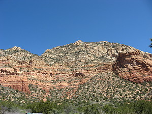
Capitol Butte is a seldom climbed mountain just west of Sedona's main strip. It separates the 89A corridor from the hikes of west Sedona. It is pretty much the only highpoint in Sedona that is right in the center of it all, and I think it has the best views in town. Unfortunately, it's not an easy hike. Instead, it is a challenging non-technical climb to what will be a well-earned summit. The Route From the trailhead at the end of Andante Drive, hike the Andante Trail northeast from the parking area. After around 1000 feet of hiking, you'll come to an obvious cross trail. Take the cross trail towards the lower slopes of Capitol Butte. The trail starts easy but gets harder as you approach the base of Capitol Butte. As you move closer, you will notice that the rough trail is taking you to an exposed area where you will make the first climb up on to a ledge. From below the climb up this pitch may look impossible, but as the trail takes you closer it becomes clear that you will be climbing up a small angled ledge which is exposed, but very possible to climb.
The next part of the climb is mostly class 2, and the trail is hard to follow at times. The general path initially continues west before turning back east, and your path may weave uphill irregularly. If you are following a trail but unsure, look for one of these two small climbs: A or B. Either one will be closer to the viewpoint than the end of the far switchback, and both will take you up to the view point which is just before you meet the rough trail coming up from the southeast drain. The viewpoint is also directly above the first pitch of climbing. After you meet the obvious trail coming up from the southeast drain, you will climb for quite a while on a fairly well-defined trail that goes back and forth between class 2 and 3. There aren't many places to go off-trail to on this climb, so if you get into a really narrow or expose area, turn back and look for the trail again. You might need to probe, and some confusing rock scrambling may be required, but there isn't too much that is all that difficult until you reach the chimney. The Chimney is the last bit of climbing you should encounter, and the trail pretty much heads right for it. It isn't all that bad going up, but it can be a little hard to go down. Make sure you think you can climb down it before going up. Looking down from on top of the chimney. You come to a small saddle from the chimney, and then it is a short stretch of trail to the summit. This is the view looking down from the saddle. You are a couple of hundred vertical feet above the chimney. Everything above the saddle is class 2 and pretty straightforward. If you think you are off route, just head up. Perhaps that is too simplistic. Going Down After you've made the summit and spent some time soaking in the magnificent views, you'll need to start heading down. It's pretty much the same as going up, except backward, and it is a little more complicated. Some of the rock is angled down and can be very slippery when descending. The route is easier to see, and it might be easier to see the trail if you had trouble coming up. If you don't want to downclimb the first section you came up, take the southeast drain. I have no experience with it, but I can say that I have heard it is much easier than the south face and much brushier.
Check out the Official Route and Triplogs. Leave No Trace and +Add a Triplog after your hike & climb trip to support this local community. | ||||||||||||||||||||||||||||||||||||||||||||||||||||||||||||||||||||||||||||||||||||||||||||||||||||||||||||||||


