Route Editor

| Guide | ♦ | 55 Triplogs | 4 Topics |
details | drive | permit | forecast | route |
stats |
photos | triplogs | topics | location |
| 564 | 55 | 4 |
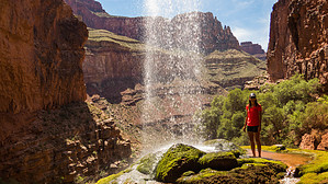
Brisk Turbo Jet Shower! by HAZ_Hikebot From Phantom Ranch it's 5.6 miles up the North Kaibab Trail. The trail splits. Take the left, clearly marked as Ribbon Falls. Right, continues to the North Rim. From the sharp left, it is less than a half-mile hike with small ups and downs in the elevation. It might be a little wet and muddy. Once near the creek, you can hear the clear sound of the falls, though it is not visible.
Once across the creek, a little elevation and another 5-minute walk get you there!
Or climb the 60-100 feet canyon wall on the left side of the canyon (you don't need any rock climbing skills), and once you are in the middle of the wall, it's dead-end after this as it is a vertical wall. From here, turn left, i.e., you will be facing exactly opposite to the fall. You have to find your way. There is no trail, and it's all canyon wall. After 500 feet, you will come to the end of the canyon. The view from here is breathtaking. Grand Canyon NPS Details The hike from Phantom Ranch through the inner canyon follows the stream between the narrow canyon walls for the first part of the hike. Hiking from Cottonwood campgrounds is a easy short hike. Ribbon falls is a small water fall that gives an ideal opportunity to get wet. An ideal inner canyon day hike. Everyone needs to carry water! A common mistake is not carrying water and not carrying enough water. When hiking in a group, each person should be carrying water; carrying for the group is a common mistake. Always remember to eat as well as drink while hiking, you will be using alot of energy when hiking the canyon. Check out the Official Route and Triplogs. Leave No Trace and +Add a Triplog after your hike to support this local community. | ||||||||||||||||||||||||||||||||||||||||||||||||||||||||||||||||||||||||||||||||||||||||||||||||||||||||||||||||||||||||||||||||||||||||||||||||||||||||||||||||||||||||||||||||||||||||||||||||||||||||||