Route Editor

| Guide | ♦ | 90 Triplogs | 2 Topics |
details | drive | no permit | forecast | route |
stats |
photos | triplogs | topics | location |
| 394 | 90 | 2 |
From Gold Diggers, Army Officers and Weather Nerds to ATVers by azdesertfather Overview
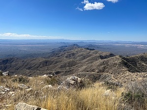
Ever been pleasantly surprised by a desert peak that almost no one talks about and gets little traffic simply due to its remoteness? Harquahala, pronounced hark-wuh-hey-luh, was one of those for me. It is a hike I had not heard of and never would have done, had Scott Warren not included it in his 100 Classic Hikes in Arizona. Prologue This hiking trail originally served as a pack trail for miners and ranchers attempting to wrest a living from the rugged and isolated Harquahala Mountains.
Different from many Sonoran Desert mountain ranges, the Harquahalas contain what the Bureau of Land Management calls a “screened interior canyon system.” The distinctive ecosystems provide exceptional natural diversity, including a relict "island" of interior chaparral, desert grasslands, and rare cactus populations. The area also supports habitat for desert bighorn sheep, mountain lions, desert tortoise, and mule deer populations, as well as venomous snakes and gila monsters. History This obscure area actually has a rich history. Harquahala caught people’s attention as early as 1869, when reportedly the Pima found gold there. In 1887 a town called Harrisburg was established there in the range, and there is a story in 1888 of three miners finding a six-pound gold nugget that at that times was worth $2000 at $20 per ounce. Over the next three days these men picked up $25,000 worth of nuggets, and the Harquahala bonanza was on. Harrisburg became a boom town, and even Wyatt Earp staked a claim near there. A 5-stamp mill that had been built was up-ended by a 20-stamp mill, crushing 60 tons of ore a day. One mine claim proved especially rich; in one 28-day period, a 309-pound bar was produced. Bars of 200-plus pounds were produced to help discourage robbery, as it would be hard to run away with, even on horseback. By 1895 the “Harquahala Glory Hole” was exhausted, and by the turn of the century, serious mining in the area was virtually over. Today, a cemetery is in the area, about 5 miles southeast of present-day Salome, Arizona. Meanwhile, in the 1880s the U.S. Army was using Harquahala Peak as a heliograph station. A couple of generations later in 1920, a Smithsonian Astrophysical Observatory was constructed on this summit and scientists lived at the peak to study variations in solar output, as a possible factor in climate prediction. The observatory was only in operation for five years before it was relocated to a site near Wrightwood, California. However, as a result of those years, a 10.5-mile 4x4 dirt road was constructed up to the peak on the opposite side of the mountain from where its hiking trailhead is located, a road that today makes the summit much more popular among the dirt quad community than the hiking community. Hike From the trailhead, the hike looks ominous, and indeed a climb of over 3,300 feet lies ahead (3,600 feet of hiking from the highway). However, the trail is not as bad as it looks. It is pretty easy to follow and is a moderate, steady incline all the way with almost no ups and downs, similar to Mt. Ord in the Mazatzals. Overall it’s a slightly steeper grade than Ord, though a few hundred feet less elevation gain. The first half of the hike is mostly a straight shot up. At one point the trail passes what looks like mine tailings, probably filling a shaft once there. In the second half of the hike up (starting at 3600 feet), there are more turns and switchbacks. Around this area are some rusted iron machinery and the wood planks left from the platform of a mining camp dating from the early 1900s, just off the trail and next to an interpretive sign. Wilderness land starts at the trailhead. About three-quarters of a mile from the summit, there is a saddle, where the wilderness land ends, and the road coming up the other side comes into view. At the top is a nice picnic table to enjoy lunch with a view, as well as a couple of buildings, some satellite dishes and several solar panels. One of the metal buildings had a sign on it speaking of native ruins. However, there was nothing there of note to be seen. There are several interpretive signs around the top that likely once told about the native history; however, years of sun and rain have destroyed them to a point they are totally illegible. Even when I hiked in February, the trail was quiet and desolate. I came across almost no one all day on the trail, so it was a surprise when reaching the peak to find nearly two dozen dirt quads and their owners that had taken the 4x4 road to the top. Warnings Please note there is really no water on this hike, no shade, and is not advisable in the summer. Also, note that a car may or may not make the drive to the trailhead. The road crosses several wadis that are ever-changing but never graded.
Check out the Official Route and Triplogs. Leave No Trace and +Add a Triplog after your hike to support this local community. | ||||||||||||||||||||||||||||||||||||||||||||||||||||||||||||||||||||||||||||||||||||||||||||||||||||||||||||||||