username
X
password
register
for free!
help
 This is likely a great time to hike this trail!  Check out "Preferred" months below, keep in mind this is an estimate.
  

Cape Royal Trail, AZ

Guide 40 Triplogs  1 Topic
  4.2 of 5  
Fav
Wish
3
details
drive
permit
forecast
route  
stats
photos
triplogs
topic
location
238 40 1
Statistics
tap row or icons for details
Difficulty 0.5 of 5
Route Finding 1 of 5
Distance Round Trip 1.2 miles
Trailhead Elevation 7,865 feet
Elevation Gain 10 feet
Accumulated Gain 50 feet
Avg Time Round Trip 30 minutes
Kokopelli Seeds 1.45
 Backpack No
unreported if dogs are allowed
editedit > ops > dogs to adjust
feature photo
Photos Viewed All MineFollowing
Will recalculate on button tap!
26  2025-06-07
Grand Canyon - North Rim
The_Eagle
15  2022-09-04
Freya Castle
FOTG
7  2019-06-15 ddgrunning
8  2018-08-31 cabel
8  2018-06-03 Tortoise_Hiker
8  2014-09-27 chumley
1  2014-09-18 Crzy4AZ
17  2013-08-30 tibber
Page 1,  2,  3
Author
author avatar Guides 21
Routes 1,182
Photos 36,858
Trips 1,570 map ( 15,177 miles )
Age 69 Female Gender
Location Phoenix, AZ
Associated Areas
list map done
Northwest Region
Historical Weather
Trailhead Forecast
Radar Map
Expand Map
Preferred Jul, Aug, Sep, Oct
Seasons   Summer to Summer
Sun  6:05am - 6:46pm
Official Route & 5 Rts
 
1 Alternative


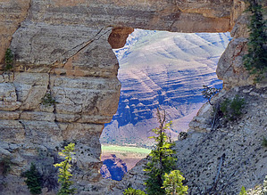
The Best Grand Cyn Vista - You decide
by tibber

 Likely In-Season!
Some say this is the best view from any of the Grand Canyon vistas... you decide. You start on a paved tree-lined interpretive signed pathway. You will see pinon trees and cliff roses with other specimen trees and flora along the way, including a Utah Juniper.


There are a couple of spots on the north side of the pathway that you can go off the path and look out across the Rim and toward Angel's Window (a somewhat square opening in the Kaibab limestone). If you get in just the right spot, you can see the Colorado River through the opening. The natural arch was caused by water seeping through the cracks, then across planes between rock beds, eventually eroding the rock from underneath.
remove free decal offer
You can opt to go north to the top of Angel's Window or continue to the tip of Cape Royal, the southernmost viewpoint on the North Rim. You are treated to a 360-degree view from the tip, with the first massive thing you see being flat-topped Wotan's Throne, a broad mesa that curves to the west. To your left, you will see Vishnu Temple and Freya Castle. And if you look across to the South Rim, you can catch a glimpse of the Watchtower at Desert View as well as the 12,633 foot Humphreys Peak of the San Francisco Peaks near Flagstaff. There is an interpretive sign that points out some of the landmarks.

As you make your way back, you will come to the walkway that goes about 150 yards out on the peninsula to the top of the fin rock that holds Angel's Window. It's quite the place to stand due to the drop-off surrounding you on three sides (there is railing/fencing that surrounds). This fin rock is made of Kaibab Limestone.

NPS Report: Cape Royal Trail 0.6 mi. / 1.0 km round-trip; 30 minutes approximate round-trip hiking time. An easy walk on a flat, paved trail providing views of the canyon, Angels Window, and the Colorado River. Markers along the trail interpret the area's natural history. Trail begins at the southeast side of the Cape Royal parking area.

2010-10-19 tibber
  • Grand Canyon Use Area Boundaries - Dynamic Map


Check out the Official Route and Triplogs.
Leave No Trace and +Add a Triplog after your hike to support this local community.
WARNING! Hiking and outdoor related sports can be dangerous. Be responsible and prepare for the trip. Study the area you are entering and plan accordingly. Dress for the current and unexpected weather changes. Take plenty of water. Never go alone. Make an itinerary with your plan(s), route(s), destination(s) and expected return time. Give your itinerary to trusted family and/or friends.

 Permit $$
None

Grand Canyon National Park
Details for each are occasionaly below numerous alerts
Entrance Fee
Overnight/Backpacking Permits
Grand Canyon Use Areas Map
Rim-to-Rim and Extended Day Hike/Run


 Directions
or
 Road
Paved - Car Okay

To hike
To reach Cape Royal from Grand Canyon Lodge, travel north on Highway 67 for three miles, turning right on Fuller Canyon Road (also known as Cape Royal Road). The road forks at about five miles, with the left fork leading another three miles to Point Imperial, the right to Cape Royal.

Take the right fork to continue toward Cape Royal, 16 miles away. The paved road is narrow and winding--watch for oncoming traffic, and take your time. A number of worthwhile sights are en route, and it's nearly impossible to backtrack if you've zipped past an enticing overlook.

The trailhead parking area is located at the end of the paved Cape Royal Road.
page created by tibber on Oct 19 2010 1:54 pm
 90+° 8am - 6pm kills
helpcorrectionissue

end of page marker