 Route Editor

| Guide | ♦ | 9 Triplogs | 0 Topics |
details | drive | no permit | forecast | route |
stats |
photos | triplogs | topics | location |
| 15 | 9 | 0 |
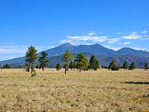
Overlooking Flagstaff by Shilo   Note NoteThis guide is written flipped from the included Official Route. The City of Flagstaff is not clear where Mesa Ridge Trail is, so this likely includes it and possibly more. When they supply better maps or details submit a correction ( bottom-center of this page ). Overview McMillan Mesa is part of the City of Flagstaff preserve. This trail is part of the Flagstaff Urban Trail System (FUTS) and the trailhead is located at Buffalo Park. It's a well-maintained trail traveling along the edge of an open grassland mesa with excellent views of the San Francisco Peaks, Mount Elden, and East Flagstaff. An impressive pedestrian bridge has recently been built over Cedar Ave. near the beginning of the trailhead. This bridge symbolizes the City of Flagstaff's focus on enhancing the urban trail systems in and around Flagstaff.
The trailhead is located at the southeast corner of the Buffalo Park trailhead. You'll see a main trail heading east and then quickly forking. Stay to the right (remember, you want to eventually go over the pedestrian bridge). The bridge takes you up and over Cedar Ave., the street you just came in on. Off to the right, you'll notice a stockyard of ciders the City uses for coating the roads during periods of snow cover. You'll quickly pass by this and be in pristine, open grass country. You'll be traveling along the eastern edge of the mesa traveling south with nice views over East Flagstaff. Several locations have park benches so that you can take a break and soak in all the beautiful views. This is also an excellent place for wildlife viewing. You'll typically see deer and all kinds of birds. At 1-mile into the hike, the trail will turn west and then take you north along the western edge of the mesa. The trail will then turn west again and terminate at a cul-de-sac on Hemlock Dr. An interesting side trail is at the southern end of the McMillan Mesa Trail that takes you further south on the mesa to a point where you can further overlook the city. This trail is not marked, but just take the jeep trail at the 1.2-mile point. At this trail junction, you also have excellent views of the San Francisco Peaks and Mount Elden. This trail gives you a nice quick and easy respite from the city life of Flagstaff. You'll immediately feel your stress leave you as you step onto this trail and proceed.
Check out the Official Route and Triplogs. Leave No Trace and +Add a Triplog after your hike to support this local community. One-Way Notice This hike is listed as One-Way. When hiking several trails on a single "hike", log it with a generic name that describes the hike. Then link the trails traveled, check out the example. | |||||||||||||||||||||||||||||||||||||||||||||||||||||||||||||||||||||||||||||||||||||||||||||||||||||||||||||||||||||||||||||||||||||||||||||||||||||||||||||||||||||


