Would I recommend a 0.8-mile hike as a destination for a 25-mile drive up the Catalina Highway? I guess not, but I would recommend finding some way to incorporate the Meadow Trail into any Loop or route you plan on doing on the top of Mt. Lemmon. It is that sweet...
The Meadow Trail exists as a small alternative route to the beginning of the Mt. Lemmon Trail. The official trailhead is about 0.1 miles into the Mount Lemmon Trail #5, located at the top of the road (Observation Road) that goes right past Ski Valley. So, hop on the Mt. Lemmon Trail and immediately look for the signed trail junction to start the Meadow Trail. Hang a right onto the Meadow Trail.
It starts as an old dirt road. There is a fenced-off observatory off to the right. To the left is forest and ferns. There are often sunflowers here, with the requisite butterflies on them. The trail is flat through here.
Shortly the flavor of the trail changes as you enter the covered pine forest proper. Some of the forest is burned, some is not. Everything is blanketed in ferns, and there is shade everywhere, cooling off those hot Tucson temperatures. There is a great earthy, pine scent in the air. There are a couple of small grassy meadows here and there. To your left, if you wander off the trail, are lovely views out over the Wilderness of Rock and upper Sabino Canyon. You could spend all day here. Up to this point, the trail is markedly level.
After roughly 0.5 miles, the trail starts to switchback down the ridge, shaded all the way. There are some lovely, huge trees along the way. Flowers and ferns too. Soon enough, you come to the signed junction with the Mt. Lemmon trail again. To the right are miles of wilderness. To the left is the route back to the Mt. Lemmon trailhead. If you hang a left here, be sure to take the short signed spur to the Lemmon Rock Lookout for some of the best views in Southern Arizona.
When hiking several trails on a single "hike", log it with a generic name that describes the hike. Then link the trails traveled, check out the example.
WARNING! Hiking and outdoor related sports can be dangerous. Be responsible and prepare for the trip. Study the area you are entering and plan accordingly. Dress for the current and unexpected weather changes. Take plenty of water. Never go alone. Make an itinerary with your plan(s), route(s), destination(s) and expected return time. Give your itinerary to trusted family and/or friends.
Four specific day-use areas require a Coronado Recreational Pass or a National Pass/America the Beautiful Pass.
1) Sabino Canyon - located on the Santa Catalina Ranger District (520)749-8700
2) Madera Canyon - located on the Nogales Ranger District (520)281-2296
3) Cave Creek - located on the Douglas Ranger District (520)364-3468
4) Mt. Lemmon at 11 day-use sites.
2025Catalina State Park
Per vehicle (1 person): $10.00
Per vehicle (2-4 people): $20.00
Individual/bicycle: $5.00
Coronado Forest MVUMs are rarely necessary to review unless mentioned in the description or directions Coronado Motor Vehicle Use Maps (MVUMs)
Directions
Road
Paved - Car Okay
To hike Take the Catalina Highway off Tanque Verde Road in Tucson. Drive 4.2 miles to the Forest boundary and continue 28 miles, past Mt. Lemmon Ski Valley, to the power substation on Radio Ridge. Hike west on the trail to a dirt road. Hike down the road to the trail junction.
The Catalina Highway is paved and suitable for passenger cars. Observatory Road is an all-weather graveled road. Both roads may be snow-covered in winter, when chains or 4-wheel drive may be required. Observatory Road beyond Mt. Lemmon Ski Valley is not maintained for public use during the winter. It is closed when snow-covered or icy.
 Route Editor

 Would I recommend a 0.8-mile hike as a destination for a 25-mile drive up the Catalina Highway? I guess not, but I would recommend finding some way to incorporate the Meadow Trail into any Loop or route you plan on doing on the top of Mt. Lemmon. It is that sweet...
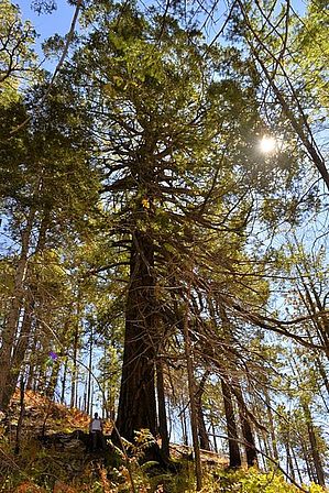


