Route Editor

| Guide | ♦ | 13 Triplogs | 1 Topic |
details | drive | permit | forecast | route |
stats |
photos | triplogs | topic | location |
| 279 | 13 | 1 |
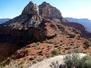
single loop roller coaster by joebartels  History HistoryTrimurti is a concept in Hinduism in which cosmic functions are personified by The Hindu Trinity. Brahma is the Hindu god (deva) of creation. Vishnu is the maintainer or preserver, and Shiva is the destroyer. Overview Up through a Redwall notch, 4 Supai obstacles, 3 Hermit shelves, scramble to Zoroaster-Brahma Saddle, traverse below Brahma then easier scrambling on Brahma. Description is based on a full day out-n-back hike, route 7375 in Route Editor starting on the South Kaibab Trail.
Class four pitches ( risk of death ) and Hermit Shale scree. Approach From Phantom Ranch, head north on the North Kaibab Trail. In just over a quarter mile, the signed Clear Creek turn-off is on the right. Follow Clear Creek Trail east about 2.6 miles to Sumner Wash. Offtrail Head north off-trail towards the redwall break. It looks a bit ominous at first glance. It's 1 mile to the top of the break. Following the wash up is a bit tedious. A use-trail surfaces under two-thirds of the way up. The joy is short-lived as the pitch increases. Your nerves should ease seeing the break is a virtual ramp. Redwall Break As you approach the break, the key ( technical bypass ) is to stay right. Scramble up a series of easy steep ledges. This is the Redwall layer. Which has a nasty tarter etched surface. Cheap thin gloves are a godsend for saving skin while maneuvering and hanging on for dear life. The second key to this ascent is a bit tricky to find. After climbing 80??? feet you go left and come back down 20 feet. Almost down to the low point, you pass a tree. It will likely have an assortment of slings to rappel the bypass. The real c4 obstacle is just ahead on the left side of the ravine. It starts on the far left. You go up maybe 15 feet. Then it's across right and continues up. The "across right" part is exposed. As of this writing, it was below a bush. Thus far, I've done this twice; each time, it takes me a few minutes to figure it out. My buddy Dave went up and across both trips without breaking stride. Continue up to the Sumner-Zoroaster saddle. Supai Next up is through a tier of Supai on the western arm of Zoroaster. After a five minute walk from the saddle to the NW tip you immediately go up 3 obstacles. All seemed under 20 feet and moderate. It seems there are several options as we took slight variations each trip. The third is a simple walk up a crack in the Supai. Soon you will be walking across the beautiful Supai arm of Zoroaster. Back from Sumner Saddle, it's 1.1 miles to the Hermit obstacles. There is one more Supai obstacle to conquer on route. It's a wide crack you chimney up 8-10 feet. Continue around to the NW side of Zoroaster. Hermit Shale 3 shelves in the Hermit are the most difficult part of the hike. The first is cake with a rope. If not, it looks to be a little c4 challenge to grip the thin crack on your right. Beware of loose dirt at the top tumbling down. The second is c3 at best. A fixed rope makes it a breeze, but you can hit it in multiple areas without. I went up halfway in one area to check. The bottom of my shoes were not clean, so I slid down. Seemed doable. The third and final shelf is the most difficult. Multiple sources call it c4. It's gotta be the upper end of such. My buddies went up like greased lightning on our second trip with the help of a fixed rope. It's currently outta my league, so I threw on a harness and was helped up. Atop the third shelf it's another 1.1 miles over the Hermit Shale. Travel over the Zoro-Brahma saddle and around the west side of Brahma to the ascent up the Coconino. Coconino Head up the coconut layer ( as jj calls it ) on the NW side of Brahma. It wasn't well marked but seemed pretty obvious. Follow a slant up towards the north tip of Brahama. Get over or around to the east side. Follow SSE to the summit. Water The proximity of Phantom Ranch makes the water situation pretty easy. Water reportedly collects in the rock face of Sumner Wash below the Clear Creek Trail. In June of 2014, I carried most of my water frozen from the SK TH on a day hike. Camping No camping between the North Kaibab/Clear Creek Trail junction and Sumner Wash, a distance of two miles. Two large trailside cairns mark the first legal camping on the west end of the Clear Creek Use Area. Camping at the south end of the Brahma-Zoro saddle looks very good. I'd imagine windy. Note Multiple sources say the Hermit shelves are in the Hermit layer. They seem like upper Supai. Calling them the Hermit shelves certainly makes them easier to distinguish from the rest of the route. Check out the Official Route and Triplogs. Note This is a difficult hike. It would be insane to attempt this entire hike without prior experience hiking. Leave No Trace and +Add a Triplog after your hike to support this local community. | |||||||||||||||||||||||||||||||||||||||||||||||||||||||||||||||||||||||||||