 Route Editor

| Guide | ♦ | 27 Triplogs | 2 Topics |
details | drive | permit | forecast | route |
stats |
photos | triplogs | topics | location |
| 409 | 27 | 2 |
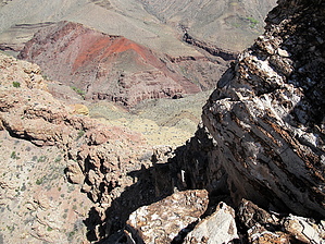
Good Harvey Day Hike by joebartels   Overview OverviewThis nice rewarding summit pronounced key-ops sits well below the rim of Grand Canyon, just two miles west of the lower North Kaibab Trail. Avid off-trail hikers with nerves of steel should be able to tackle the adventure. Warning The risk factor makes a capable partner a wise choice. Loose angled footing on route uses stabilizer muscles few use regularly. The ridge is a crumbly mess. A good set of lungs may aid in screaming.
This makes for an excellent day hike from the South Rim in October or March, in my opinion. Most will probably find it more enjoyable after a night's rest at Phantom Ranch or Bright Angel Campgrounds. Of course, then you have to deal with the red tape circus act and plan ahead. Aside from early October, if the North Rim is open, it's probably too hot to consider from that angle. Regardless of your approach, you will need to understand the Utah Flats Route. Unless you are dropping off Tiyo Point in the backcountry, most will be coming from BA Campgrounds. This is where the Utah Flats Route begins, exactly 7 miles from the South Rim via SK. It's another 2 miles to the turnoff for Cheops Plateau. Hike to NW Ridge The NW ridge is the ticket for a non-technical ascent. The least enjoyable part is getting from Utah Flats to a saddle(not really, feels like it) at roughly 4,940ft on the NW ridge. After three trips I recommend the posted official route. The terrain is very steep and unstable in places. In my experiences, the further you put off ascending, the worse it gets. There is a crude use-trail under the NE facing wall you will be traveling under. So thoughts of saving time by following UFR closer to the saddle are null and void. In fact, that takes longer contouring the larger ravines at the bottom followed by a doomsday approach up the largest unstable scree slope I pray I never have to set foot on again. NW Ridge This is the fun or scary part, depending on your perception. I recommend gloves. Some of the rock has a sandpaper tarter type finish which is sharp. Call it whatever "class" you want; you will need to use your hands to assist yourself up the ridge obstacles. It's 400 ft to the top. About 300 ft up, you come to the crux, which is a gut-wrenching obstacle. Once I figured it out, it seemed more fun than scary. Crux It's more mind over matter verse a physical feat. The ridge narrows to maybe 15 ft. What makes it scary is you leave the safety of the ridge and move left to get up. The exposure is unknown if you don't look down (hint). The moment you look down, the Vegas odds on your completion drop faster than tweety bird with a steel anvil tied to its back. After two failed attempts I watched video of others ascending. It became pretty obvious my fears were out of control. The handholds are excellent. The issue I had was after sliding left. I couldn't figure out how to go up. There is a handhold under a rock that worked so well (on my third attempt) the whole ordeal was over before I had much time to think about it. Basically, I needed to steady myself with the underhand to gain a higher reach. Then it was more fun than scary. The remaining ridge is sketchy in spots, but at least you are on the ridge instead of hanging off the side. Soon you pass left of an arch / window. I've been told to stay off as walking over might weaken the structure. Plateau Stable ground... ahh! It's a half-mile across to the southern edge. Along the way, you can find a trail register. A Boston Museum of Science triangulation survey marker is difficult to miss. Grand Canyon reminds you how tiny you are with incredible wide-open views. You can see the SK & BA trails from a perspective few see. The killer view is standing on the southern edge looking over across a wicked narrow bridge to Cheops Pyramid. Water None after leaving BA CG. Since you cross Bright Angel Creek, you might want to bring a filter. On our April 2013 visit, I used the drinking water faucet outside the restrooms. The iodine is typically very noticeable. On this visit, it was also cloudy and silty. Stats
Check out the Official Route and Triplogs. Leave No Trace and +Add a Triplog after your hike to support this local community. One-Way Notice This hike is listed as One-Way. When hiking several trails on a single "hike", log it with a generic name that describes the hike. Then link the trails traveled, check out the example. | ||||||||||||||||||||||||||||||||||||||||||||||||||||||||||||||||||||||||||||||||||||||||||||||||||||||||||||||||||||||||||||||||||||||||||||||||||||||||||||||||||||||||||||||||||||


