Route Editor

| Guide | ♦ | 9 Triplogs | 0 Topics |
details | drive | permit | forecast | route |
stats |
photos | triplogs | topics | location |
| 77 | 9 | 0 |
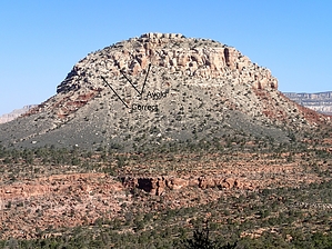
By the book! (Buy the book?) by chumley  Overview OverviewMt. Huethawali is a prominent peak that rises 1000-feet above the Darwin Plateau about two miles north of the South Bass trailhead. It is a dominant feature on the landscape for any hiker descending the South Bass Trail or traversing the eastern portion of the Esplanade Route. Most of the peak is surrounded by steep cliff faces that make ascending it impossible without technical climbing gear. However, an easier route exists and allows simple class-3 scrambling along the southwest slope. Name Pronounced "wee-the-wally", some sources indicate that Huethawali is a Native American term which means "Observation Point", but Wayne Tomasi explains in his book that it is a Havasupai term that means "white tower, white rock mountain, or mountain of white stone." It is a descriptive term since the Coconino sandstone it is composed of is whiter than the terrain it protrudes from.
The easiest approach to Huethawali is from the southwest. First, you must get there, and the obvious route is to descend on the South Bass Trail past the Esplanade junction, a little more than a mile and about 1200 feet below the rim. Whenever it seems right, leave the Bass trail and head in a general northwesterly direction across the Darwin Plateau, aiming for the left corner of the mountain in front of you. This terrain is tiresome, with numerous small drainages to cross, strewn with large boulders and shin-eating desert scrub. Occasionally you may find a game trail, but they last only for a short stretch before you are once again searching for the best route. Upon reaching Huethawali's southwest corner, begin climbing along the best-looking route. As you climb, occasional cairns will begin to funnel you to a fairly-well-established route. The climb here is on loose scree, with occasional large slabs of Coconino sandstone providing more sure footing. The climb is steep in places, but rarely are hands required. Before gaining the summit, you will have to ascend a couple of short climbs through the top layer of Coconino sandstone, though there are two or three possible routes to follow. Once on top, the mountain stretches for several hundred yards in a mostly-flat ridge. Be sure to head all the way to the northeast portion for better easterly views and take the time to admire the view to the north that had been blocked from view during your entire trip thus far. The return trip follows the same route back, though you will almost certainly not be able to follow your route across the Darwin Plateau. Here it is good to have an eye for the South Bass Trail and make your way toward it for the climb back to the trailhead. Caution This hike involves off-trail class-3 scrambling on loose scree-covered slopes. There is no trail! This is a very remote part of the canyon, and there is no water available. This hike should only be attempted by those who are experienced and comfortable hiking off-trail in the Grand Canyon and other desert locales. Check out the Official Route and Triplogs. Note This is a moderately difficult hike. Leave No Trace and +Add a Triplog after your hike to support this local community. | |||||||||||||||||||||||||||||||||||||||||||||||||||||||||||||||||||||||||||||||||||||