 Route Editor

| Guide | ♦ | 60 Triplogs | 1 Topic |
details | drive | permit | forecast | 🔥 route |
stats |
photos | triplogs | topic | location |
| 318 | 60 | 1 |
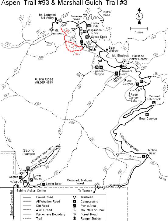
Can I offer you a mint? by fricknaley  Note NotePage statistics reflect #20 one-way segment. The description below is for a 3mi / 960 aeg / 1.5hr shuttle. Overview The Mint Spring trail offers yet another little meandering trail up on Mt. Lemmon, perfect for adding on to other routes. The Aspen/Marshall Loop, in particular, goes well with a hint of Mint. This trail can be accessed both from Carter Canyon Road in Summerhaven or its terminus at Marshall Saddle. I will describe it from Marshall Saddle because it just seems to fit in so well on a Marshall/Aspen loop hike.
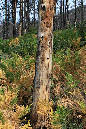
From Marshall Saddle a sign points the way north (Mint Spring #20). The trail is narrow and pretty easy to follow. It cuts through heavily burned areas most of the way. There is a lot of ground cover/regrowth, with tons of ferns. There is very gentle up-and-down along the way. The trail cuts over a couple of ridges first, dropping down then over the intervening washes. Currently, these were dry washes, but after true monsoons, I'm sure they flow. There is a lot of penstemon and geraniums along the way. Also the farther you go, the thicker the ferns become to the point of just coating the hillsides. It is pretty sweet. Lots of birds flickering about too. You will cross over 3 such washes along the way as you head into thicker and thicker fern cover. This area is really kind of interesting. After about a mile, you start to gently climb up to a type of saddle and everything changes in a flash as you cross over, then swing left. Now you are along a steep embankment/wall with the trail falling away severely to your right and climbing up to your left. The burned trees here are surrounded by tall grass. At the bottom of the slope to your right is a level plateau. Through the burned trees, you will see the full extent of Summerhaven and all the rebuilding cabins. What a strange and unique view. I was somewhat bewildered for a while. After about 0.6 miles along this section, the trail starts to switchback down Carter Canyon and ultimately ends at the gravel road, which serves as the other signed trailhead from which to start this hike. Take notice, on the last stretch of this trail near the Carter Canyon end, there are a lot of leg-level thorns. If you hike in shorts be prepared for some scratches.
Check out the Official Route and Triplogs. Leave No Trace and +Add a Triplog after your hike to support this local community. | |||||||||||||||||||||||||||||||||||||||||||||||||||||||||||||||||||||||||||||||||||||||||||||||||||||||||||||||||||||||||||||||||||||||||||||||||||||||||||||||||||||||||||||||||||||||||||||||||||||||||||||||


