Route Editor

| Guide | ♦ | 79 Triplogs | 3 Topics |
details | drive | no permit | forecast | route |
stats |
photos | triplogs | topics | location |
| 657 | 79 | 3 |
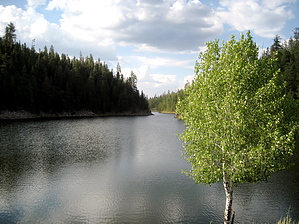
Hike, swim, fish by chumley  2017 Note 2017 NoteListed as #112 on old FS topo maps. Current topo maps show #506. One sign suggests different. Overview Bear Canyon Lake Trail #112 isn't as much of a hike, rather a destination. The Sitgreaves National Forest has designated the trail along only the west side of Bear Canyon Lake. However, the trail continues around the entire circumference, maintained by regular traffic from anglers.
Hike The areas near the parking lots tend to have more people enjoying the shore, so if you're looking for solitude, pick a direction and start walking. I headed south toward the head of the lake. The trail is easy to follow and gets plenty of traffic. Because the lake is in a fairly steep canyon, most of the trail is not on level ground but the steep slopes leading into the lake. Despite the slope, the hiking is easy, with few obstacles and good footing. At the south end of the lake, the terrain flattens out, and the trail passes through an open grassy meadow and the two drainages that feed the lake. Between the drainages is a beautiful point with a lone Aspen tree overlooking the lake. Signs indicate that camping is prohibited, though a couple of fire rings show that not everybody has always followed these rules. There's a spur trail here that leads up the hill to the south and a vehicle access point at the end of FR208. From the lake's head, the trail heads back north along the eastern shore, a similarly steep slope. After about a mile, the trail heads to the right around an inlet that opens the lake to its widest point. It continues from here to the dam, where another access trail leads up a closed road to the north. Cross the dam and head back down the shore to the trail you used to access the lake. A short climb back out of the canyon will have you in your car. This lake tends to be busy on weekends in the summer. Weekdays or early/late season visits will be much more peaceful. Thankfully, the short, steep hike to the lake prevents the boombox and beer crowd. If you're just in for a beautiful hike, this can be done in a little over an hour, or if you want to take it leisurely, bring a picnic and relax at the head of the lake or near the dam for a while. I took a few swimming breaks as the weather was great, and the water was clear and cool. Check out the Official Route and Triplogs. Leave No Trace and +Add a Triplog after your hike to support this local community. | ||||||||||||||||||||||||||||||||||||||||||||||||||||||||||||||||||||||||||||||||||||||||||||||||||||||||||||||||||||||||||||||||||||||||||||||||||||||||||||||||||||||||||||||||||||||||||