Overview
Love or hate it; you have to admit, it's convenient! The large parking lots bring large crowds. Regardless, this is a great hike. If crowds get you down try the Circumference Trail. (claimed one of the best wildflower shows in Arizona).
Okay, so your heart is set on the summit. The route is an old horse path. Some of the railings are still in place up near the mile mark. An old mine was the primary use for the trail[1]. You can forget exploring that area as it is off-limits. So stay on the path and keep out of trouble! Plenty of restrooms are available in the parking areas. It's great to wash your face off after a hike in the summer heat.
Hike
The trail starts with a few switchbacks. A wider than average pathway handles the crowds reasonably well. At times it gets incredibly crowded. Then there are times you luck out, and a beautiful day will go by with only a few visitors. In passing, I've heard conversations about how Piestewa compares to Camelback. Camelback, while statistically more challenging, is smoother. An extra 100 feet of elevation, two steep handrail sections, and a few stretches through boulder fields give it the "tougher" nod. The footing on Piestewa is typically more jagged yet generally no steeper than a staircase.
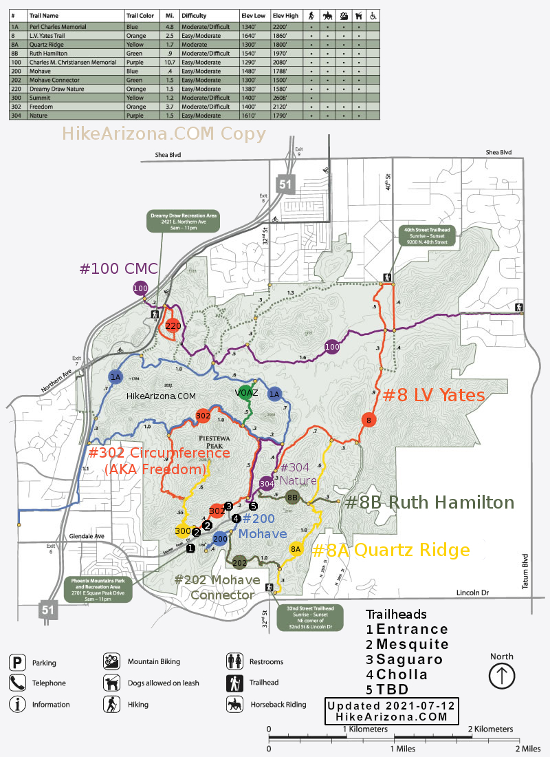
Several benches along the way provide comfort. Passing the 0.25-mile marker, you are in switchbacks. Between the 0.45 and the 0.6-mile marks, the trail flattens out. The Circumference Trail spurs off to the left and then down away at the halfway point 0.6 miles. Continue up the next series of switchbacks that start immediately after the 0.6-mile marker. The second section of the flat trail opens up after passing the 0.75-milepost. Enjoy the stroll and relax as the nasty parts are yet to come. The path goes in and out of the contours with a minor elevation gain for a short distance. Welcome to never-ending switchbacks. It's something like thirteen in a row. The first being the least forgiving as it is steep, and the footing is slightly loose. After that, it's not lousy footing wise. The third takes you up to an often utilized bench. After the fourth switchback comes the most significant step with exception near the summit. ( now gone, this trail receives a lot of volunteer maintenance ) On Camelback, these are the kind of long-legged steps you battle over and over again. You encounter more steep slopes passing the one-mile mark. However, it's nothing to worry about as the steps are small and close together, just like a staircase.
Okay, it's on to the summit. Believe it or not, only a small percentage of the crowd makes it up to the official peak. Most are satisfied with the larger area just a few yards shy of the summit. It's fun to look around and see the city from a birds-eye view. I prefer the sheer drop off from Camelbacks summit, which adds a real sense of elevation! Piestewa Peak is an excellent alternative when you can't get into the Camelback parking lot!
Note
You are in a preserve. Taking home rocks or even moving them is prohibited. Leave the wildflowers in place. Only park in designated areas. Do not cut switchbacks. Over the years, I have seen rangers hand out tickets for all of the above. An illegal parking ticket puts a damper on the ride home. An old, obviously blocked trail that cuts up the dreaded switchbacks has tempted this cowboy. Forget it, it's stupid and isn't worth it, period.
Rangers
Over the years, I have met many rangers on the trail. They are friendly, helpful, and do a great job.
[1] 2014 - 17 years later I'm not sure on my source. Met a man named John that farmed in the area back in the '60s. He said the city paid them 5k to construct the trail to the top in 1965. I asked if it was originally a mining trail that ended near the horse rails, and he said no. I asked if it was built for recreation, and he said yes. He also stated that burros were used rather than horses to build the trail. People did take horses up often back in the day.
WARNING! Hiking and outdoor related sports can be dangerous. Be responsible and prepare for the trip. Study the area you are entering and plan accordingly. Dress for the current and unexpected weather changes. Take plenty of water. Never go alone. Make an itinerary with your plan(s), route(s), destination(s) and expected return time. Give your itinerary to trusted family and/or friends.
Permit $$
None
Directions
Road
Paved - Car Okay
To hike Between 16th and 24th Streets on Lincoln Drive, go North on Piestewa Peak Dr. Follow Piestewa Peak Dr through the neighborhood into the park.
 Route Editor

 Overview