Route Editor

| Guide | ♦ | 29 Triplogs | 3 Topics |
details | drive | no permit | forecast | route |
stats |
photos | triplogs | topics | location |
| 170 | 29 | 3 |
Forbidden Peak by Jim  Hiking Agassiz Peak is only legal when it is covered by snow. Ascending Agassiz peak during snow-free conditions can result in a $500 fine. While you can set out to hike this peak from other locations, leaving from the Snowbowl ski area is the best and easiest route to take. This is because all other roads are closed and any other trailheads are at much lower elevations. The free backcountry permit has not been required since it was phased out in 2019. Hiking Agassiz Peak is only legal when it is covered by snow. Ascending Agassiz peak during snow-free conditions can result in a $500 fine. While you can set out to hike this peak from other locations, leaving from the Snowbowl ski area is the best and easiest route to take. This is because all other roads are closed and any other trailheads are at much lower elevations. The free backcountry permit has not been required since it was phased out in 2019.When most people look at the San Francisco Peaks from Flagstaff, they see two pointed peaks. Often, tourists and those unfamiliar with the Peaks assume that the large pointy one on the left is Arizona's highest point: Humphrey's Peak. This is not accurate, as Humphrey is only visible from Flagstaff through Fremont Saddle. The large pointy peak on the left is Agassiz Peak. The other lower one is Fremont, which is also a good hike.
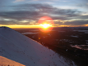
There is good news though. For cold tolerant individuals who enjoy winter activities that do not involve chair lifts, it is possible to legally hike Agassiz Peak when covered in snow. All you need are lots of warm and dry clothing, some snowshoes, and a desire to do something that most who hike Humphrey in summer will never do. It is also important to remember water, despite the snow. It might be tempting to use the snow for water, but there can be algae on the snow which can cause mild to severe digestive problems. There is bad news though: there is no trail. The trail you could take lies buried under many inches to several feet of snow. Hiking the ski slopes is not allowed. If you want to, you could take the Agassiz chairlift to the top and then hike the rest of the way up, but that is cheating. A more realistic approach is to find and take the Snowbowl snow-cat trails to the ski patrol hut, or backcountry hike upslope with your snowshoes through deep soft snow. There are two easy ways to head up to the peak. The first is the safest and most direct: take the west ridge from the Agassiz lodge to Agassiz Peak. This can be steep, but it is very easy to follow and you can't get lost, just head up. As you go up, the mountain narrows and forces you toward the top of the Agassiz chairlift. Once there, continue up past the ski patrol hut towards the false summit and then to the true summit. Beware of winds above the tree line. They can be extremely fierce. This is the best route to follow as it has the lowest likelihood of an avalanche. The second route is to head upslope into the backcountry north of the Sunset Ski Slope towards the saddle. This route is slightly more difficult and it can require some skill. It may be better to keep your path more to the north and away from the bowl that forms the upper part of Snowbowl. The steepness of the upper bowl will probably force you towards Humphrey's Saddle. Once there proceed up the ridge towards Agassiz Peak. Once again beware of the winds. You will be very exposed on this ridge, and if you venture too far to one side you may run the risk of being in avalanche territory. The traverse from the saddle to the peak is about 3/4 of a mile, so be prepared for what could be a long hike in harsh, really harsh conditions. Once on the Summit of Agassiz Peak, you will be treated to something few will see: an unobstructed view of all the terrain east, south, and west of the Peaks. Bring your camera and take plenty of pictures. If the weather is good, make some phone calls and brag. Unlike Humphrey, no one else will be there to get annoyed. Heading down can be tricky. The safest way down is likely the way you came up. It can take a while to go back down, but if you ski you might just want to head down one of the Snowbowl runs-if allowed. Otherwise, you can snowshoe, woods ski, or roll down the hill like a big snowball; whatever suits your fancy. Once back at your vehicle you can rest and enjoy what may have been one of the hardest hikes you will ever do.
Check out the Official Route and Triplogs. Note This is a difficult hike. Arrive fit and prepared or this could get ugly. Leave No Trace and +Add a Triplog after your hike to support this local community. | |||||||||||||||||||||||||||||||||||||||||||||||||||||||||||||||||||||||||||||||||||||||||||||||||||||||||||||||||||||||||||||||||||||||||||||||||||||||||||||||||||||||||||||||||||||||||||||||