 Route Editor

| Guide | ♦ | 32 Triplogs | 1 Topic |
details | drive | no permit | forecast | 🔥 route |
stats |
photos | triplogs | topic | location |
| 449 | 32 | 1 |
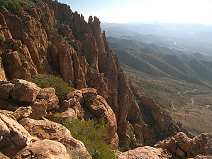
Kiss it goooodBYE by PrestonSands  This is a description of an off-trail hike up the east side of the sprawling cliff known as Apache Leap. It is by no means the only route up to Apache Leap. Most of the shallow canyons on its east side should provide do-able off-trail routes. You can also create a loop by taking a different canyon back to your starting point. Potential hikes here are limited only by your time and enthusiasm. This is a description of an off-trail hike up the east side of the sprawling cliff known as Apache Leap. It is by no means the only route up to Apache Leap. Most of the shallow canyons on its east side should provide do-able off-trail routes. You can also create a loop by taking a different canyon back to your starting point. Potential hikes here are limited only by your time and enthusiasm.The mileage listed is an approximate minimum distance for any hike up the east side. The entire area is a vast, trail-less boulder field covered in chaparral and catclaw mimosa, so expect slow cross country travel.
Hike There is a decent-sized pull-off area along the Magma Mine Road (forest road 469) near its junction with forest road 315, making a fine starting point for any hike to Apache Leap. You can also drive or hike south along Forest Road 315 to access other canyons that lead southwest to Apache Leap. I chose to park at the pull-off and hike further along FR 469 to a gently sloping canyon on the left, at the 4040-foot contour. Initially narrow and full of potholes, this canyon soon opens up into a shallow, boulder-filled valley. A continuous series of small cairns mark a route that follows the creek bed up the canyon's bottom. The cairns are not entirely necessary as the canyon's terrain is relatively open, but they seem to lead away from the catclaw's worst patches. The canyon sides here are lined with bizarre rock formations carved from cemented volcanic ash. After a mile or so, the canyon gets a little steeper, and the cairned route soon tops out on the rim of Apache Leap, at around 4700 feet. At this point, the route turns south, and the cairns continue along the top of Apache Leap. I was satisfied with reaching the edge, so I did not continue further but instead made my way over to an open, rocky knoll to enjoy the view of all points south and west. The Superstition and Pinal Mountains are the skyline attractions up here, while Highway 60 runs through the town of Superior and the rugged maw of Queen Creek Canyon, some 2000 feet below. A peek over the edge of Apache Leap reveals a sheer drop of over 500 feet. According to legend, Apache Leap is the site of a mass suicide of Apache warriors sometime during the early 1870s. The story goes that the U.S. Cavalry attacked a group of Apaches camped on top of Apache Leap, and a battle broke out. The Apaches were eventually driven to the very edge of the enormous cliff. Rather than surrendering, the Apaches chose to leap over the cliff to their deaths. Have fun, enjoy the view, and don't fall off! Check out the Official Route and Triplogs. Leave No Trace and +Add a Triplog after your hike to support this local community. | ||||||||||||||||||||||||||||||||||||||||||||||||||||||||||||||||||||||||||||||||||||||||||||||||||||||||||||||||||||||||||||||||||||||||||||||||||||||||||||||||||||||||||||||||||||||||||||||||||||||||


