Overview
Boulder Canyon Trail #103 spans from Canyon Lake TH to the Dutchman Trail #104. Which is the Boulder Basin where Boulder Creek forks into East, Little & West Boulder Creeks.
This trail is somewhat misnamed. The first half-mile from the Canyon Lake Trailhead allows views of Boulder Canyon. However, it quickly turns away to a climb up Frog Peak. Descending from the peak, you approach and cross La Barge Canyon before finally getting into Boulder Canyon, which you follow for the remainder of the trail. Day hikers rarely make it to Boulder Canyon.
Hike
Starting from Canyon Lake Marina, park at the designated spots for hikers and cross Apache Trail. The trail in this section allows views of the inlet created where Canyon Lake flooded the original lower reaches of boulder canyon. The trail climbs to a hill, providing some glimpses of the lake inlet and interesting mesas to the west. From the hill, the trail proceeds east, climbing for Frog Peak. (This hill is the departure point for "La Barge Lowest Loop"). After a steady climb to the peak, you will be given an incredible view across Canyon lake and be able to see as far as the interesting alcove with the waterfall north of Tortilla Flats, admire the enormous cairn created on this peak. I do not know the history of this monstrous cairn, so if someone has some information on this, please send me a PM.
From here, you descend on the somewhat rocky trail on the way down to La Barge Creek. Suggested side trips for this area are: "La Barge Canyon View". You have an excellent view of the stern of Battleship Mountain as you descend.
After reaching the creek bed, the trail crosses to the west side and begin a minor ascent over the saddle. (The crossing is the departure point for "La Barge Lower-Box Loop")
At the saddle between La Barge Canyon and Boulder Canyon on the trail, you will come upon the Indian Paint Mine. The pit that they extracted red clay to make their paints and pottery is still apparent, and the nearby "furnace" area is still discernible.
Descending into Boulder Canyon proper, the trail crosses Boulder Creek to reach the trail's west side. Shortly you will run into the first intersection with Second Water Trail. Continue on south on the Boulder Canyon Trail. From here, the trail gets a bit more rugged and less defined as it follows along Battleship Mountain. It tends to stay close to the sides of the creek but makes frequent crossings. Cairns should lead you in the right direction, but the area is somewhat over-cairned in areas leading to some confusion. It is generally rocky, and the creek bed contains some catclaw, shrub live oak, and other vegetation.
The canyon is relatively narrow, but the slope of the climb is gradual. Next, you'll reach the intersection with the Cavalry Trail #239. The intersection is signed. However, if you are not on the creek's east side at this point, you may miss it. Continue south on the Boulder Canyon Trail.
Before the end, you will see Needle Canyon entering from the east, which looks mighty formidable. Finally, the trail winds its way to flatter ground on the west side. Closely watching for cairns will lead you to the official intersection with the Dutchman, which is also very close to the Bull Pass Trail #129 and somewhat near Black Mesa Trail #241. These intersections are well signed. Be warned that this final intersection is relatively indistinct. Pay careful attention to find where the trail finally leaves the creek. I would consider it likely some will miss the trail and pop out on either the Bull Pass or somewhere along the Dutchman, which may lead to some confusion. I have given directions to two groups of perplexed folks I've found standing at this intersection, some with GPS, and I believe this is the cause of the most confusion.
Weaver's Needle's views are motivation to go all the way to the end of the Boulder Canyon but turn around as your fitness level and time before darkness dictate if doing a day hike.
There is a small restaurant at the Marina, which a hungry hiker may find to their advantage.
Boulder Creek is seasonal. Caution should be exercised crossing either La Barge or Boulder Creeks if it has rained recently. During a storm flash, floods are a real possibility at these crossings due to the tremendous area these creeks are responsible for draining. 3-5 feet of flowing water can take down a grown man. If intending to camp, it would be best to obtain a water report for Boulder Creek as it is typically dry in the summer.
o Partial out-n-back hikes, you'll need to adjust your mileage, elevation gain & accumulated elevation gain
- To Second Water Trail #236 (and back) is 8.0 mi, 650' EG, 1600' AEG
- To Indian Paint Mine (and back) is 7.0 mi, 650' EG, 1450' AEG
- To La Barge Creek (and back) is 5.75 mi, 650' EG, 1300' AEG
o Backpack loops and others starting on #103
- Post a triplog from here
- Adjust your mileage, elevation gain & accumulated elevation gain
- After it post, link other trail segments using the Linked feature!
When hiking several trails on a single "hike", log it with a generic name that describes the hike. Then link the trails traveled, check out the example.
WARNING! Hiking and outdoor related sports can be dangerous. Be responsible and prepare for the trip. Study the area you are entering and plan accordingly. Dress for the current and unexpected weather changes. Take plenty of water. Never go alone. Make an itinerary with your plan(s), route(s), destination(s) and expected return time. Give your itinerary to trusted family and/or friends.
Permit $$
None
Directions
Road
Paved - Car Okay
To Canyon Lake Trailhead From the junction of Idaho Road & SR-88 follow SR-88 14.4 miles east to just after mile marker 210. Turn left into the Canyon Lake Marina parking lot. The area closest to the SR-88 (furthest away from the Marina) is the actual trailhead parking. The area allowed is marked in front of each space.
There's restrooms outside the restaurant. The restaurant is better than you might think for being out in the middle of nowhere. Try the stuffed Jalapeños, the berry sauce is awesome. Sit on the patio and watch the HUGE fish swim below. The 'Dolly' Steamboat (a tourist attraction) is way out of character for the area, but the snowbirds eat it up.
From PHX (I-10 & AZ-51) 49.7 mi - about 1 hour 6 mins From TUC (Jct 1-10 & Grant) 143 mi - about 2 hours 23 mins From FLG (Jct I-17 & I-40) 194 mi - about 3 hours 10 mins
 Route Editor

 Overview
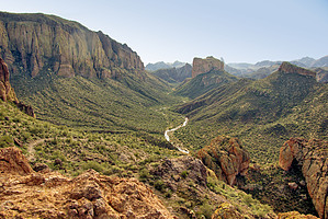


