username
X
password
register
for free!
help
 

Keyhole Canyon, NV

Guide 9 Triplogs  0 Topics
  3 of 5  
Fav
Wish
0
NV > Vegas
details
drive
no permit
forecast
map
stats
photos
triplogs
topics
location
16 9 0
Canyons are inherently risky. Flash floods occur without notice on sunny days. Technical skills & surrounding topography knowledge required yet does not eliminate risk.
Statistics
tap row or icons for details
Distance One Way 0 miles
Trailhead Elevation 2,843 feet
 Interest Off-Trail Hiking
feature photo
Photos Viewed All MineFollowing
16  2010-04-23 AZLOT69
Author
author avatar Guides 16,843
Routes 17,472
Photos 24
Trips 1 map ( 6 miles )
Age 28 Male Gender
Location HAZ, TrailDEX
Historical Weather
Trailhead Forecast
Expand Map
Preferred Apr, Oct, Nov, May
Sun  5:18am - 5:54pm
0 Route
 
0 Alternative


remove free decal offer

Guide Needed
Publish Full Detail Guide


Use +Add above to share photos and triplogs
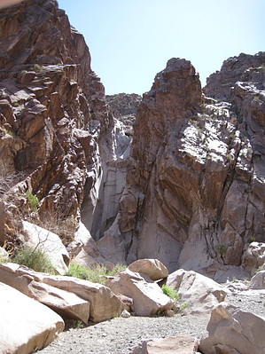
While most of the petroglyphs are around the mouth of the canyon it is fun to scramble on the house sized boulders, looking. A short hike into the canyon will have you come abruptly to an eighty foot sheer dryfall. With anchors present on the wall, it is obviously a place climbers frequent. There is a scree chute on either side of the dryfall making for nice views from above.


    Check out the Triplogs.
    Leave No Trace and +Add a Triplog after your canyon trip to support this local community.
    WARNING! Hiking and outdoor related sports can be dangerous. Be responsible and prepare for the trip. Study the area you are entering and plan accordingly. Dress for the current and unexpected weather changes. Take plenty of water. Never go alone. Make an itinerary with your plan(s), route(s), destination(s) and expected return time. Give your itinerary to trusted family and/or friends.

     Permit $$
    no fees or permits reported

    if incorrect tell us about it


     Directions
    or
     Road


    To canyon trip
    Highway 95 south of Las Vegas towards Searchlight. Watch for mile post 41. Drive .6 mile to next left turn marked with a white cattle guard. Head east for two miles on this dirt road. There are three sets of power lines ahead. Take the second dirt road located between the second and third power lines to the right. Proceed 1.7 miles to a power pole marked 23E3. Take the dirt road to the left here to the parking area.
    page created by AZLOT69 on Apr 26 2010 11:26 am
    helpcorrectionissue

    end of page marker