Route Editor

| Guide | ♦ | 23 Triplogs | 2 Topics |
details | drive | no permit | forecast | route |
stats |
photos | triplogs | topics | location |
| 384 | 23 | 2 |
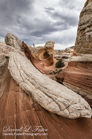
The double Arch fooled me by kanode   White Pocket is in an area of swirling twisted multicolored rock 5 miles due east of the Cottonwood Teepee trailhead. You can see the White Pocket monolith from some of the high points at Cottonwood Teepees. White Pocket can be visited on its own or as part of a trip to South Coyote Buttes. The road is a 4WD high clearance road due to soft powdery sand and sand ruts. Snow or rain may also make the road impassable. The drive took 50 minutes for 8.5 miles over frozen sand on a January trip. If you can make the drive to Cottonwood Teepees, the drive from there to White Pocket is just more of the same. White Pocket is in an area of swirling twisted multicolored rock 5 miles due east of the Cottonwood Teepee trailhead. You can see the White Pocket monolith from some of the high points at Cottonwood Teepees. White Pocket can be visited on its own or as part of a trip to South Coyote Buttes. The road is a 4WD high clearance road due to soft powdery sand and sand ruts. Snow or rain may also make the road impassable. The drive took 50 minutes for 8.5 miles over frozen sand on a January trip. If you can make the drive to Cottonwood Teepees, the drive from there to White Pocket is just more of the same.A BLM permit is not required for White Pocket, so this trip is a good substitute if you can't obtain a permit for Coyote Buttes.
I suspect the White Pocket monolith is named for the pockets in the "brain" rock near the trailhead, but I haven't been able to confirm that. In any case, there are about a dozen pockets in the rock. They are off to your right at a 45-degree angle at the end of the path from the parking area. You'll also notice an impressive double arch in the cliffs to the east. I took several photos of the arch, including some with a 12X zoom. I didn't realize until cropping the photos at home that it's not an arch but merely two shallow alcoves in the cliff. Check out the Official Route and Triplogs. Leave No Trace and +Add a Triplog after your hike to support this local community. | |||||||||||||||||||||||||||||||||||||||||||||||||||||||||||||||||||||||||||||||||||||