Route Editor

| Guide | ♦ | 16 Triplogs | 0 Topics |
details | drive | permit | forecast | 🔥 route |
stats |
photos | triplogs | topics | location |
| 83 | 16 | 0 |
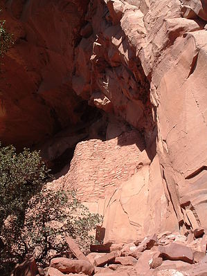
  The Sinagua ("without water") Indians once lived across a vast swath of land, stretching from north of Flagstaff down through the Verde Valley. They disappeared from the archaeological record by 1450, with the northern branch probably beginning to meld into the early Hopi culture. The southern Sinagua's fate is less clear. Some experts have suggested that warring or hostile invaders may have driven the Sinagua away or killed them all. Others postulate that they moved south to the Phoenix Basin to join the Hohokam around 1300 when most of the Colorado Plateau was undergoing a colossal population relocation. This may be true, as the first "Sinagua" were probably, in fact, Hohokam settlers who later adopted some northern, Anasazi, cultural traditions. The Sinagua ("without water") Indians once lived across a vast swath of land, stretching from north of Flagstaff down through the Verde Valley. They disappeared from the archaeological record by 1450, with the northern branch probably beginning to meld into the early Hopi culture. The southern Sinagua's fate is less clear. Some experts have suggested that warring or hostile invaders may have driven the Sinagua away or killed them all. Others postulate that they moved south to the Phoenix Basin to join the Hohokam around 1300 when most of the Colorado Plateau was undergoing a colossal population relocation. This may be true, as the first "Sinagua" were probably, in fact, Hohokam settlers who later adopted some northern, Anasazi, cultural traditions.Honanki, a Hopi word meaning "Bear House," is one of the best places to see what the Sinagua life was like in the late 1200s. Located just a few miles away from Palatki Pueblo, and contemporaneous with it, this large cliff dwelling gives a great idea of how populous the Sedona area was back then.
From the parking area, cross the road and stop at the information booth. A Forest Service volunteer or employee staffs this during the day when the ruin is open. There is no fee, but you are required to sign your name and group size so that the FS can monitor site usage. The person will then briefly talk about Honanki, etiquette, and rattlesnakes, which are common during the summer. Then you are left to your own devices. Heading north from the booth, you will come across a branch in the trail. Stay to the left - you'll come out after the ruin on the path to the right. As you continue north across the rolling pinon-juniper forest, look through the trees at the base of Loy Butte; you can catch a glimpse of Honanki. After the trail bends right and brings you up against the cliff, you are at Honanki. There is a fair amount of rock art at this site. Some of it located relatively high. Some of these high images are hard to imagine someone painting at - how did they reach it? Most of the main cliff dwelling of Honanki is closed to exploration, but you can take a small spur up into the alcove. When this ruin was built in the late 1100s, it filled the entire alcove and spilled out onto the valley floor, along the cliff's base. Quite the complex! This site was much larger than nearby Palatki, or the other well-known Sinagua cliff dwelling of Montezuma's Castle. Please take a few minutes to imagine how the ruin would have looked when it was whole, filled with a bustling population of people, turkeys, and dogs. After climbing back down from the alcove, follow the trail further south along the cliff face. There are more rooms here, some that were at least two stories tall when the pueblo was completed. There are also more rock art images. Look for round "shield" designs. Some people have suggested that these were hexes for the Anasazi, but what they meant for the Sinagua is unknown. They are somewhat common throughout the Sinagua heartland (several can be found at Palatki), suggesting their role in life may be more prosaic than cursing someone. They may have been identifiers for the village or the people living there. Keep your eye out also for several human figures, one who appears to be a flute player. Another may be a dancer (Air Jordan, tinyelvis called it). After soaking up as much of the ruin as you want, keep hiking along the cliff face until the trail bends right again. This will eventually take you back to the fork in the trail north of the booth, and from there back to your car. Please note that there is no water on this trail. Fill your water bottles in Sedona or elsewhere before beginning this hike.
Check out the Official Route and Triplogs. Leave No Trace and +Add a Triplog after your hike to support this local community. | ||||||||||||||||||||||||||||||||||||||||||||||||||||||||||||||||||||||||||||||||||||||||||||||||||||||||||||||||||||||||||||||||||||||||||||||||||||||||||||||||||||||||||||||||||||||||||||||||||||