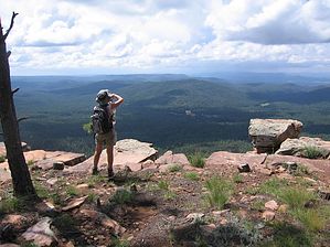
This is a delightful hike through a healthy pine forest filled with great views from the Mogollon rim. Sun_Hiker and I did this hike in 2005 and 2008 for the second time. The trails involved include the Sinkhole, Rim Vista, Drew Canyon, and part of the Highline trail from its intersection with the Drew trail to its eastern endpoint at the 260 trailhead where the loop starts and ends. These trails are in good to excellent condition and are relatively easy to follow. There are a few fallen trees across the trails but all are easy to step over or hike around.
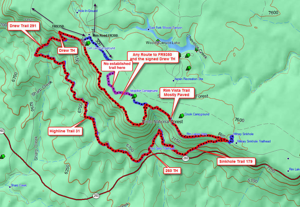
From the 260 TH turn right and we took the Sinkhole trail 179 for 2.3 miles and about 1,000 feet of elevation gain to the top of the Mogollon Rim. The Sinkhole trail is a nice hike through pine forest that is easy to follow as it turns into an old unused dirt road after a mile or so as it climbs up to the rim. At several points along the way, some good viewpoints reveal the terrain below the rim. Just as you get to the end of the Sinkhole Trail (at the trailhead), there is now a gate across the trail that you will have to climb over. Once on top of the rim after a visit to the actual Military Sinkhole, we followed the Rim Vista trail for about 2.5 miles along the rim. Here we had continuous views from the rim. About 2.0 miles of this trail is paved and has handicapped access from several viewpoint parking areas along the way. Most likely there will be some rim visitors on this segment only.
After 2.5 miles we continued for another 2.0 miles to the drew Trailhead. In our 2005 hike, we stayed close to the rim for this part and in 2008 we were closer to Rim road. It doesn't matter how this part is hiked. If you stay south of Rim Road as shown in the graphic below you will intersect FR9350 which you will follow south to the signed Drew trailhead. FR9350, a well-traveled dirt road, itself intersects Rim Road. If you travel the north route through Mogollon Campground, the trail ends there. You can blaze a trail to the northwest through the forest, or just follow Rim Road to Carr Lake Campground if you're not as adventurous. As long as you don't cross Rim Road (or fall off the Rim), you'll end up at the confluence of Rim Road 300 and FR9350 near Drew trailhead. This campground (Carr Lake Campground) is between the two roads, so if you followed Rim Road, you can pass through the campground to FR9350. There is a sign-off of FR9350 directing to the Drew trailhead on the left.
At the Drew trailhead, there are 2 posts you hike between to begin your descent of about 1.1 miles to the Highline trail. Be watchful for the small sign-off to your left, so that you don't miss the turn for the Highline Trail going east. Otherwise, you'll end up on the Highline Trail going west toward the See Canyon trailhead. This is also a beautiful forested area. At the intersection with the Highline trail, there appears to be a fork in the trail. Stay left to continue the hike for about 4.7 miles on the Highline trail that gets you back to the 260 trailhead. This part of the Highline is also very scenic and was a delight to hike again. We both enjoyed the entire hike!!
Gate Policy: If a gate is closed upon arrival, leave it closed after you go through. If it is open, leave it open. Leaving a closed gate open may put cattle in danger. Closing an open gate may cut them off from water. Please be respectful, leave gates as found. The exception is signage on the gate directing you otherwise.
WARNING! Hiking and outdoor related sports can be dangerous. Be responsible and prepare for the trip. Study the area you are entering and plan accordingly. Dress for the current and unexpected weather changes. Take plenty of water. Never go alone. Make an itinerary with your plan(s), route(s), destination(s) and expected return time. Give your itinerary to trusted family and/or friends.
Permit $$
None
Directions
Road
Paved - Car Okay
To Two-Sixty Trailhead From Payson take 260 east. About 5 miles past the second exit to the Christopher Creek loop slow down, watch your back and turn left just past the sign to the 260 trailhead. The turnoff is past Colcord Road and marker 278. There is parking and a permanent toilet at this trailhead.
From PHX (I-10 & AZ-51) 114 mi - about 2 hours 8 mins From TUC (Jct 1-10 & Grant) 212 mi - about 3 hours 28 mins From FLG (Jct I-17 & I-40) 138 mi - about 2 hours 33 mins
 Route Editor


 This is a delightful hike through a healthy pine forest filled with great views from the Mogollon rim. Sun_Hiker and I did this hike in 2005 and 2008 for the second time. The trails involved include the Sinkhole, Rim Vista, Drew Canyon, and part of the Highline trail from its intersection with the Drew trail to its eastern endpoint at the 260 trailhead where the loop starts and ends. These trails are in good to excellent condition and are relatively easy to follow. There are a few fallen trees across the trails but all are easy to step over or hike around.