 Route Editor

| Guide | ♦ | 98 Triplogs | 0 Topics |
details | drive | permit | forecast | 🔥 route |
stats |
photos | triplogs | topics | location |
| 206 | 98 | 0 |
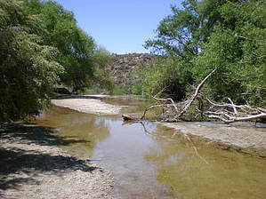
Easy Access to Water by PhilipMueller   If you are in Tucson and looking for some easy access to water in the desert, check out the short lasso loop hike to the Sabino Dam. After stopping at the Sabino Canyon Visitor Center & Bookstore amble down Bear Canyon Trail #29 for 0.8 miles. The trail runs parallel with the road, but except for the occasional tourist tram, you're away from modernity and focused on the views of the Pusch Ridge Wilderness in the distance and the rich Sonoran Desert flora in the foreground. Head north off of Bear Canyon Trail onto Sabino Lake Trail #30 and you'll walk above and parallel to the creek for about 0.6 miles. If you are in Tucson and looking for some easy access to water in the desert, check out the short lasso loop hike to the Sabino Dam. After stopping at the Sabino Canyon Visitor Center & Bookstore amble down Bear Canyon Trail #29 for 0.8 miles. The trail runs parallel with the road, but except for the occasional tourist tram, you're away from modernity and focused on the views of the Pusch Ridge Wilderness in the distance and the rich Sonoran Desert flora in the foreground. Head north off of Bear Canyon Trail onto Sabino Lake Trail #30 and you'll walk above and parallel to the creek for about 0.6 miles.Shortly after passing Bluff Trail #51, which you can take to Upper Sabino Canyon Road, you'll cross the creek and head south on Sabino Dam Trail. On Sabino Dam Trail, you are pretty much walking in the creek bed for 0.3 miles to the dam. It's like a mini-mini Aravaipa with trees lining the water's edge and canyon walls framing the scene. Lots of great spots in those 3 tenths of a mile to relax in the shade, splash in the water, or soak up some sun--whatever your pleasure. Just beyond the dam, you have to make your own trail for about 0.1 mile west across the creek and climb back up to Sabino Lake Trail, on which you retrace your path back to the visitor center.
Check out the Official Route and Triplogs. Leave No Trace and +Add a Triplog after your hike to support this local community. | |||||||||||||||||||||||||||||||||||||||||||||||||||||||||||||||||||||||||||||||||||||||||||||||||||||||||||||||||||||||||||||||||||||||||||||||||||||||||||||||||||||||||||||||||||||||||||||||||


