Route Editor

| Guide | ♦ | 9 Triplogs | 0 Topics |
details | drive | no permit | forecast | map |
stats |
photos | triplogs | topics | location |
| 125 | 9 | 0 |
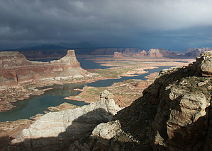
A trip with a view by PaleoRob  Alstrom Point provides one of the most memorable, scenic, and widely photographed views of Lake Powell. While the actual hiking at the point is limited, half of the enjoyment of this location is the trip to get there. Warning Alstrom Point is very remote. Although you can see the city of Page, it will take you between 1.5 to 3 hours to get there. There is no gas along the way. Water is not available except in Wahweap Creek, just outside of Bigwater, which flows muddy. The road is primarily on the Tropic Shale, which can turn into a mud bog after rain or snow. The last mile or two into Alstrom Point is over rough slickrock and not well marked in places.
From the parking area, wander around the rim. There are beautiful views of Navajo Mountain, the Kaiparowitz Powell, and Lake Powell. Be aware that the cliffs may be undercut, so do not get too close to the rim. Spend time wandering and taking in the views. In April and May the wildflowers, such as Indian Paintbrush and Lupine, are in bloom. In the summer you can have fantastic views of storms sweeping across Navajo Mountain. Be careful not to disturb the cryptobiotic soil that abounds in some places. When you are done exploring, return to your vehicle. Most people spend most of their time at Alstrom Point looking out, and not hiking, so expect to cover less than a mile. The exception to this is if you have a lower-clearance vehicle. You can park your vehicle at the first large slickrock area and hike the remaining mile and a half to Alstrom Point. Water Sources None. Camping Dispersed camping locations are plentiful, especially along the 350/Alstrom Point road. Remember to pack out whatever you pack in. Check out the Triplogs. Leave No Trace and +Add a Triplog after your hike to support this local community. | ||||||||||||||||||||||||||||||||||||||||||||||||||||||||||||||||||||||||||||||||||||||||||||||||||||||||||||||||||||||||||||||||||||||||||||||||||||||||||||||||||||||