Route Editor

| Guide | ♦ | 14 Triplogs | 0 Topics |
details | drive | permit | forecast | route |
stats |
photos | triplogs | topics | location |
| 323 | 14 | 0 |
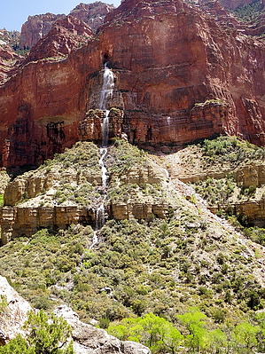
Ellsworth thought intermittent by Al_HikesAZ   Note NoteMultiple-day backpack for most. Guide stats only represent the final off-trail stretch. Background Cheyava Falls is the tallest waterfall in Arizona - beating out Angel Falls, Seven Cataracts, and Carr Falls. Cheyava also rates as the highest in Magnitude and Aesthetics in AZ.
History Ellsworth Kolb named the Falls. "After the USGS river trip in the summer of 1923, Colonel Claude H. Birdseye suggested that Ellsworth give it a name, preferably of Indian origin. Ellsworth supposed the water flowed only intermittently, and he suggested Cheyava, a Hopi word meaning intermittent river" Hike First, you have to get to the Trailhead at Clear Creek Campground. Many hikers go to Bright Angel Campground or Phantom Ranch on Day One (an 8 to 10-mile trip) and then to Clear Creek Campground on Day Two (a 9 to 10-mile trip). Physically fit and experienced Backpackers can make it to Clear Creek Campground in one day (an 18 to 20-mile trip) depending on the weather and temperatures. See the Clear Creek Trail Description. If Cheyava Falls is running and worth seeing, you will get wet on this hike so have appropriate footwear and dress accordingly. At times you will walk in the creek and you will cross it many times. Starting from the Clear Creek Campground, head up creek. Access to the upper region of Clear Creek and Cheyava Falls begins with a fairly narrow section through the Shinumo cliffs that surround the camping area at the end of the Clear Creek Trail. The recent erosion of the streambed has created (or re-created) a small waterfall obstacle but it seems easy enough to step across above the falls rather than climbing up from below. Depending on the volume of flow, getting started upstream could be a problem. We had several substantial creek crossings. We then found a faint but reasonably well-defined trail through thickets of horsetail, permitting much faster hiking than bushwhacking through the brush or working your way up the shallow creek. The first half-mile or so is the brushiest and the toughest to follow; then the canyon opens up. The canyon branches about a mile north of the camping area. Stay right and follow the creek bed northeast past cottonwood trees and striated cliffs toward the North Rim. Obi Canyon comes in from the west and the flow may diminish slightly; streamflow decreases again above the next western fork with Ariel Canyon. The way to Cheyava Falls turns east into what seems like a lesser drainage but is the longest arm. Thor Temple is on your right. Note the contrast in vegetation as you make your way north. The area near the creek is a lush riparian habitat while just a few yards away is a parched desert landscape, scattered with yucca and beavertail cactus. Although you don't notice it much, you gain more than 1,000 feet of elevation during the approach to the Falls, giving you great vistas on your return hike down-canyon. Back at Clear Creek camp high above to the southeast are The Howlands Butte and Dunn Butte, named after the three men who abandoned Powell's first expedition prematurely at Separation Canyon and were never seen again (O.G. Howland, Seneca Howland, and Willam H. Dunn). Low stone walls have been built at the camps to mitigate the winds. The winds can be a blessing to keep the gnats away. USGS Topo Maps for Phantom Ranch and Walhalla Plateau are helpful. Check out the Official Route and Triplogs. Note This is a moderately difficult hike. Leave No Trace and +Add a Triplog after your hike to support this local community. | |||||||||||||||||||||||||||||||||||||||||||||||||||||||||||||||||||||||||||||||||||||||||||||||||||||||||||||||||||||||||||||||||||||||||||||||||||||||||||||||||||||||||||||||||||||||||||