Short hike to a transient (Spring) 60 ft falls connecting Wolf Creek to the Hassayampa. The hike involves some scrambling down a steep sandy trail to the bottom of the falls. It is about a mile round trip. The creek and falls are typically dry.
A nice option is to continue down to a nice scenic area on the Hassayampa River. This river is typically dry too.
WARNING! Hiking and outdoor related sports can be dangerous. Be responsible and prepare for the trip. Study the area you are entering and plan accordingly. Dress for the current and unexpected weather changes. Take plenty of water. Never go alone. Make an itinerary with your plan(s), route(s), destination(s) and expected return time. Give your itinerary to trusted family and/or friends.
Only trailheads with six "amenities" have fees. Amenities are picnic tables, trash, toilet, parking, interpretive signing and security.
Directions
Road
FR / Dirt Road / Gravel - Car Okay
To Wolf Creek Trailhead To access the trail from Prescott, travel south on Mount Vernon Avenue which changes to Senator Highway, then Forest Road 52, for approximately 6 miles to Groom Creek. Continue past Groom Creek to just beyond where the pavement ends. Turn right on Wolf Creek Road ( FS97 / County Road 101 ). Follow Wolf Creek Road 1.6 miles to a small loop trailhead on the right.
From PHX (I-10 & AZ-51) 2 h 5 min (113 miles) From TUC (Jct 1-10 & Grant) 3 h 27 min (218 miles) From FLG (Jct I-17 & I-40) 1 h 54 min (102 miles)
 Route Editor


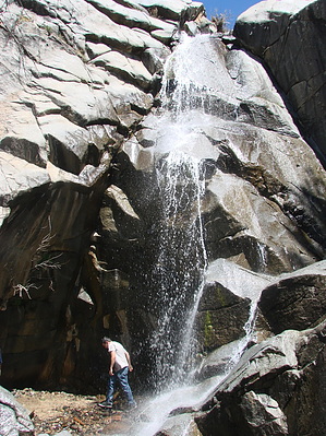
 Short hike to a transient (Spring) 60 ft falls connecting Wolf Creek to the Hassayampa. The hike involves some scrambling down a steep sandy trail to the bottom of the falls. It is about a mile round trip. The creek and falls are typically dry.