username
X
password
register
for free!
help
  This is likely a great time to hike this trail!  Check out "Preferred" months below, keep in mind this is an estimate.
  

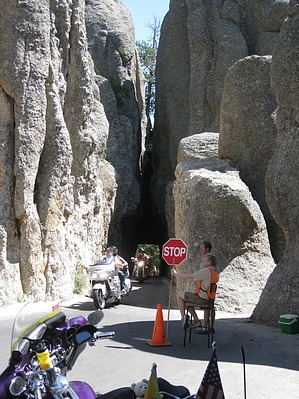
Peter Norbeck Scenic Byway, SD

Guide 4 Triplogs  0 Topics
  4 of 5  
Fav
Wish
0
details
drive
permit
forecast
map
stats
photos
triplogs
topics
location
4 4 0
Statistics
tap row or icons for details
Distance One Way 68 miles
Trailhead Elevation 5,204 feet
 Interest Historic, Seasonal Waterfall, Perennial Waterfall, Seasonal Creek & Perennial Creek
unreported if dogs are allowed
editedit > ops > dogs to adjust
feature photo
Photos Viewed All MineFollowing
19  2019-07-25
Spokane - Ghost Town
AZLOT69
4  2010-08-12 AZLOT69
Author
author avatar Guides 16,843
Routes 17,472
Photos 24
Trips 1 map ( 6 miles )
Age 28 Male Gender
Location HAZ, TrailDEX
Historical Weather
Trailhead Forecast
Expand Map
Preferred Sep, May, Jun, Oct
Sun  6:29am - 7:12pm
0 Route
 
1 Alternative


remove free decal offer

  Likely In-Season!
Guide Needed
Publish Full Detail Guide


Use +Add above to share photos and triplogs
Overview: A must do in the Black Hills, also known as the needles highway. Nice views of Mt Rushmore, pig tail bridges and one lane tunnels add to the fun. Almost a certainty to see wildlife. The Custer State Park charges admission. $ 10.00 motorcycle- $ 12.00 car/2 people-$ 15.00 car/more than 2 people, good for 7 days.


    Check out the Triplogs.
    Leave No Trace and +Add a Triplog after your scenic drive to support this local community.
    WARNING! Hiking and outdoor related sports can be dangerous. Be responsible and prepare for the trip. Study the area you are entering and plan accordingly. Dress for the current and unexpected weather changes. Take plenty of water. Never go alone. Make an itinerary with your plan(s), route(s), destination(s) and expected return time. Give your itinerary to trusted family and/or friends.

     Permit $$
    information is in description


     Directions
    or
     Road
    Paved - Car Okay

    To scenic drive
    This loop road starts at highway 16 and the intersection of highway 87/89 and proceeds south.
    page created by AZLOT69 on Aug 21 2010 8:24 am
    helpcorrectionissue

    end of page marker