Route Editor

| Guide | ♦ | 32 Triplogs | 3 Topics |
details | drive | permit | forecast | route |
stats |
photos | triplogs | topics | location |
| 429 | 32 | 3 |
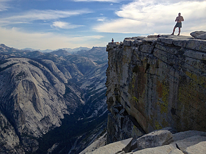
Premier Landmark by John9L Half Dome was originally called "Tis-sa-ack" by the Native Americans who lived in Yosemite Valley before white settlers moved in. The name refers to a mother from native legend and they say her face can be seen in Half Dome. Around 1850, white settlers started entering the valley. It was declared that Half Dome was "perfectly inaccessible" and would never be summited. This was proved differently by George Anderson. Anderson was a blacksmith living in Yosemite and spent several weeks drilling and placing eyebolts into the smooth granite on the eastern side of Half Dome during 1875. He would be the first to summit. In 1919, the Sierra Club funded the replacement of Anderson's eyebolts with the current braided steel cables we see today. Overview Half Dome is one of the premier landmarks in Yosemite National Park. It is known throughout the world and has been immortalized in photos by Ansel Adams. The summit can be achieved by either hiking at least 8 miles one way on one of the several trails or by taking on the multiday rock climb up the face.
There are multiple hiking routes to choose from. The most common is via the Happy Isle trailhead on the valley floor. You can also start at Glacier Point on the Panorama Trail. Another option would be starting at Tenaya Lake off the Tioga Pass. See the backcountry office for overnight options. Whatever option you choose plan ahead and be prepared for a full day of hiking. In general, a day hike to the summit and back will take 10 to 12 hours. You'll cover at least 16 miles and 4,800 of AEG. Starting from Happy Isles, you head up the Mist Trail. See the Mist Trail for more details. To summarize, you work your way up to the top of Vernal Falls and then continue to the top of Nevada Falls. The top of Nevada Falls is roughly 3.5 miles and 2,000 of AEG. From there, you head into Little Yosemite Valley on a smooth grade for the next mile. The trail is well marked. From the campground in Little Yosemite Valley, you turn north and will begin working your way up into the forest on a gentle and consistent grade of switchbacks. Views are limited due to the tall trees in the area. After a little over a mile, you come to the turn-off for Clouds Rest and Tenaya Lake. Tenaya Lake is one of the alternative starting points for this hike. Continue up the trail towards Half Dome. As you continue up, you gain elevation and several views open up. Clouds Rest looms to the east. It sits 1,000 feet higher than Half Dome. As you work your way up, the east side of Half Dome slowly comes into view. Trees continue to block your view until you get closer. Finally, a break in the trees appears and it provides a clear view of the summit. From there the trail turns west and heads towards the summit. You know you're close when you reach the switchbacks on sub-dome. Take your time and work your way up. Be careful when passing people. As you work your way up sub-dome the view of the cables becomes clear. You can see the ant-like people spread out working their way up or down. The climb up the cables looks very intimidating and you wonder if this is a good idea. Of course it is! When you reach the bottom of the cables, you can either pick up a pair of gloves from the stack at the bottom or bring your own pair. Gloves will protect your hands on the cables. Also, check your pack to make sure everything is secured. If the cables are crowded wait your turn and then begin working your way up. Climbing the cables takes teamwork with those around you. Make sure you have good footing whenever you need to stop. Also, be careful with those heading in the opposite direction. Most important take your time and be careful every step of the way. The granite is very slick on the cables due to the years of hikers going up and down. Work your way up and you'll reach the summit in a few minutes. The summit of Half Dome is a huge open area that covers several acres. Take your time to explore and enjoy the views. You're rewarded with a 360-degree view of Yosemite. To the west sits Yosemite Valley. To the east sits Clouds Rest. Tenaya Canyon lays to the northeast and Mount Starr King to the south. Take some pictures and eat some lunch. From here, you need to head back down the cables and then return to either camp or Yosemite Valley. The return trip is almost all downhill and goes by fast. Once back to Yosemite Valley, take a moment to gaze at Half Dome. You've conquered the summit and will see it in a different light. Be proud of your accomplishment! Caution Half Dome is struck by lightning every single month throughout the year. On July 27, 1985, five hikers were struck by lightning, resulting in two fatalities. See the book called Shattered Air by Bod Madgic for details. Use your head when you approach the cables and don't risk the summit if bad weather is present. You can either wait it out or try another day. In general, summer storms move in late in the afternoon. Try to be on your way down by early afternoon.
Check out the Official Route and Triplogs. Note This is a more difficult hike. It would be unwise to attempt this without prior experience hiking. Leave No Trace and +Add a Triplog after your hike to support this local community. | |||||||||||||||||||||||||||||||||||||||||||||||||||||||||||||||||||||||||||||||||||||||||||||||||||||||||||||||||||||||||||||||||||||||||||||||||||||||||||||||||||||||||||||||||||||||||||||||||||