Route Editor

| Guide | ♦ | 12 Triplogs | 0 Topics |
details | drive | permit | forecast | 🔥 route |
stats |
photos | triplogs | topics | location |
| 21 | 12 | 0 |
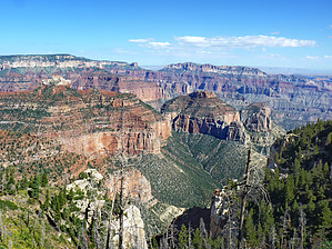
View worthy of the honor by tibber  Roosevelt Point was dedicated in 1990 in honor of the 26th President, who played an essential role in creating the Park. It is about 1/2 way between Bright Angel Point and Cape Royal on the Walhalla Plateau. From the small parking lot on the north side of the road, a trail leads downhill to a couple of benches at a viewpoint that extends 4 miles east. Roosevelt Point was dedicated in 1990 in honor of the 26th President, who played an essential role in creating the Park. It is about 1/2 way between Bright Angel Point and Cape Royal on the Walhalla Plateau. From the small parking lot on the north side of the road, a trail leads downhill to a couple of benches at a viewpoint that extends 4 miles east.A little east is the rock formation called Tritle Peak at 8,388 feet. It's made of Kaibab Limestone. There are several other red buttes in the distance. You really can see quite a bit as you look north. If you go to Point Imperial, it is on the other side of this area along the Cape Royal Road.
A little way along the road as you drive toward Cape Royal is the Walhalla Overlook, where you can see the Unkar Delta of the Colorado River. Grand Canyon NPS Reports: Roosevelt Point Trail 0.2 mi. / 0.3 km round-trip; 20 minutes approximate round-trip hiking time. This trail is a short, secluded woodland loop with spectacular views. Offers benches for relaxed enjoyment of the canyon. Check out the Official Route and Triplogs. Leave No Trace and +Add a Triplog after your hike to support this local community. | ||||||||||||||||||||||||||||||||||||||||||||||||||||||||||||||||||||||||||||||||||||||||||||||||||||