Route Editor

| Guide | ♦ | 32 Triplogs | 2 Topics |
details | drive | no permit | forecast | map |
stats |
photos | triplogs | topics | location |
| 366 | 32 | 2 |
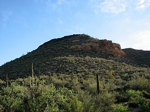
Dutchman gold hunters found here by CannondaleKid  If you've hiked the Black Mesa Trail, Black Mesa Loop, or the south half of Boulder Canyon Trail, you've hiked right on by this peak, which just happens to be named Yellow Peak. If you view it from a southerly direction you will notice the "yellow" rock escarpment from which the peak got its name. While you can approach it from the south or north from either Boulder Canyon Trail or the Black Mesa Trail, if you want to do it in the shortest distance, begin at the First Water TH, follow Second Water Trail until you get to the Black Mesa Trail intersection, turn right onto this trail and continue about 2 miles to where the trail drops down to creek level and turns northeast before turning southeast away from the creek. At this point, you should decide first, whether to make your approach to the Yellow Peak summit and second whether as a round-trip or out-and-back. Depending on your choices it will vary from 1 to 2 or more miles added onto your Black Mesa trek. The Yellow Peak-specific track I'll is about 1.6 miles. If you've hiked the Black Mesa Trail, Black Mesa Loop, or the south half of Boulder Canyon Trail, you've hiked right on by this peak, which just happens to be named Yellow Peak. If you view it from a southerly direction you will notice the "yellow" rock escarpment from which the peak got its name. While you can approach it from the south or north from either Boulder Canyon Trail or the Black Mesa Trail, if you want to do it in the shortest distance, begin at the First Water TH, follow Second Water Trail until you get to the Black Mesa Trail intersection, turn right onto this trail and continue about 2 miles to where the trail drops down to creek level and turns northeast before turning southeast away from the creek. At this point, you should decide first, whether to make your approach to the Yellow Peak summit and second whether as a round-trip or out-and-back. Depending on your choices it will vary from 1 to 2 or more miles added onto your Black Mesa trek. The Yellow Peak-specific track I'll is about 1.6 miles.Hike Starting from First Water TH, stay on the Second Water Trail #236 for about 1.8 miles to the Black Mesa Trail #241. Turn RIGHT on the Black Mesa Trail and continue 2.0 to 2.1 miles depending on whether you want to do a clockwise or counter-clockwise loop up to the Yellow Peak summit and on around. For a CW loop, I'd recommend leaving the Black Mesa Trail at or near 33.46926 -111.40302 For a CCW loop, I'd recommend leaving the Black Mesa Trail at or near 33.46844 -111.40047
If you do an out-and-back to the summit only, I'd recommend approaching from the south, which will be the shortest. My GPS track features an approach from the west climbing up the WNW slope. While it was steep, it was easy enough to climb the large rocks almost like stepping stones. If you are planning the loop and want to climb up the rocks, I'd recommend climbing sooner than I did (from leaving Black Mesa Trail in the creek bed) on the west slope. Otherwise, continue farther around to the north end than I did and have an easier but ~0.2 mi longer trek. If you want to experience the whole works, I'd recommend taking the south route up, across the summit and down N to the first saddle and a few smaller 'bumps' then down to the east across a lower saddle, climb the small peaks that face east over Boulder Canyon, then you can either loop southeast or northeast down to the Boulder Canyon Trail, traverse NW around the north end or traverse across to the south and around to the west back to the Black Mesa Trail. There is so much to see and such fabulous views (Battleship, Geronimo Head, Malapais Mountain, Black Top Mesa, Black Mesa, and Weaver's Needle, and even the west ridgeline of the Superstitions) you'll want to take your time. Oh yeah, and if you think the Dutchman's gold is on this peak... well, have at it, but be careful, you don't want to be pushing up daisies, or whatever grows around here. One last thing... while I was here in late January, I don't doubt much of the peak will be a rattlesnake haven/heaven in the warmer months. I walked through numerous areas chock full of holes (and caved in many) that just spoke rattler to me. Note #1 The stats for this hike reflect only the distance, time, and elevation gain from the point you leave and return to the Black Mesa Trail #241. When planning this hike make sure you allow for the time out and back on the Black Mesa Trail from First Water TH. Be sure to link either Black Mesa Loop or Second Water/Black Mesa Trail #241 to your triplog. Note #2 Depending whether you do an out-and-back from the south or do the "Full Monte" as described above, the AEG will range between 500' and 850'. Your mileage will also vary from 0.8 to 2.0 if you are prone to wander. Check out the Triplogs. Leave No Trace and +Add a Triplog after your hike to support this local community. | ||||||||||||||||||||||||||||||||||||||||||||||||||||||||||||||||||||||||||||||||||||||||||||||||||||||||||||||||||||||||||||||||||||||||||||||||||||||||||||||||||||||||||||||||||||||||||||