 Route Editor

| Guide | ♦ | 9 Triplogs | 0 Topics |
details | drive | no permit | forecast | route |
stats |
photos | triplogs | topics | location |
| 10 | 9 | 0 |
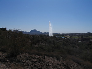
nice kiddie hike by DarthStiller  The Lake Overlook Trail is an urban trail in the heart of Fountain Hills that is short and easy to hike. The total length is only 1.5 miles, but some additional walking is required along Fountain Lake to get back to the trailhead. Depending on your mood and your company, a longer hike around the lake after completion can stretch a hike out to 3 miles or more. This is an excellent family hike for kids and people who aren't die-hards (which is probably you, if you're reading this). The Lake Overlook Trail is an urban trail in the heart of Fountain Hills that is short and easy to hike. The total length is only 1.5 miles, but some additional walking is required along Fountain Lake to get back to the trailhead. Depending on your mood and your company, a longer hike around the lake after completion can stretch a hike out to 3 miles or more. This is an excellent family hike for kids and people who aren't die-hards (which is probably you, if you're reading this).Start at the east parking lot of Fountain Lake, just off of Panorama Boulevard. Cross Panorama and head north (left) just a bit, and you'll see a short, green, metal sign that points out the beginning of the Lake Overlook Trail.
After 0.3 miles, you get past the condos, and the trail turns north on a ridge. Up here, you're away from the housing, but still not far from it. However, the views are much better because you now have a 360-degree vista of the surrounding mountains. To the east now, the Superstitions and Four Peaks are visible, and to the north, you can make out Mount Ord and the Mazatzals. Much more of the McDowells are visible, especially as they stretch to the north. At the 0.7 mile mark, the trail drops down the hillside and back through some more condo development. Some views of the mountains and lake are still visible, however. Soon the trail ascends and switchbacks up a hill and levels off again, heading west and then south. At this point, the "trail" makes its way out a sidewalk and basically through a neighborhood. Follow the sidewalk west again for a block or two until you see the sign for the Lake Overlook Trail and turn left (south). From here, the trail is back on singletrack. There is some slight switchbacking at first, but then a gradual descent southward towards the Foutain, which is visible for most of this section. Once the trail ends at the intersection of Saguaro and Palisades Boulevards, you can either take a direct route back to your car or hike around the lake some more. The south end of Fountain Lake has some playgrounds and a splash park, which is likely to be of some interest if you're hiking with kids, for which this hike is well suited. Check out the Official Route and Triplogs. Leave No Trace and +Add a Triplog after your hike to support this local community. One-Way Notice This hike is listed as One-Way. When hiking several trails on a single "hike", log it with a generic name that describes the hike. Then link the trails traveled, check out the example. | |||||||||||||||||||||||||||||||||||||||||||||||||||||||||||||||||||||||||||||||||||||


