Lake Creek Trail #378 accesses the southern portion of the Strawberry Mountain Wilderness in eastern Oregon's Blue Mountains. Highlights include hiking along a perennial creek in a glacial cirque, a 12' waterfall, and a beautiful high alpine lake. The trailhead is located just north of Logan Valley at the end of forest road 924 where there is a small parking area and trail register.
The hike begins gradually gaining elevation following Lake Creek north through a forest of ponderosa and lodgepole pine. Several spring complexes that feed into Lake Creek cross the trail for the first two miles. Dead and downed logs criss-cross the trail as well, remnants from the High Roberts Fire of 2002 that burned in this portion of the wilderness.
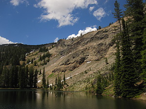
Around the two mile mark the trail begins to gain elevation rapidly as it approaches the falls on Lake Creek. From here the trail levels out for another mile before making the final climb to High Lake. At 3 miles in the trail crosses the creek; split log bridges make for easy creek crossings. Immediately after crossing the creek the trail again climbs steadily towards High Lake. The High Lake Trail #385 connects here from the left, be sure and follow the trail to your right for the most direct approach to High Lake. The trail will once again cross Lake Creek, but at this point High Lake is in full view. After exploring High Lake return to the trailhead by way of Lake Creek Trail.
When hiking several trails on a single "hike", log it with a generic name that describes the hike. Then link the trails traveled, check out the example.
WARNING! Hiking and outdoor related sports can be dangerous. Be responsible and prepare for the trip. Study the area you are entering and plan accordingly. Dress for the current and unexpected weather changes. Take plenty of water. Never go alone. Make an itinerary with your plan(s), route(s), destination(s) and expected return time. Give your itinerary to trusted family and/or friends.
Permit $$
None
Directions
Road
FR / Jeep Road - Car possible when dry
To hike From Burns, OR head north on US 395 for 45 miles to the town of Seneca. In Seneca turn right on to Forest Service 16 road for 18 miles to Logan Valley. Turn right on to FR 924 and stay on till road ends in 4 miles. Road ends at Lake Creek Trailhead.
 Route Editor


