username
X
password
register
for free!
help
  This is likely a great time to hike this trail!  Check out "Preferred" months below, keep in mind this is an estimate.
  

Garden Creek, AZ

Guide 20 Triplogs  0 Topics
  4.7 of 5  
Fav
Wish
3
details
drive
permit
forecast
map
stats
photos
triplogs
topics
location
166 20 0
Canyons are inherently risky. Flash floods occur without notice on sunny days. Technical skills & surrounding topography knowledge required yet does not eliminate risk.
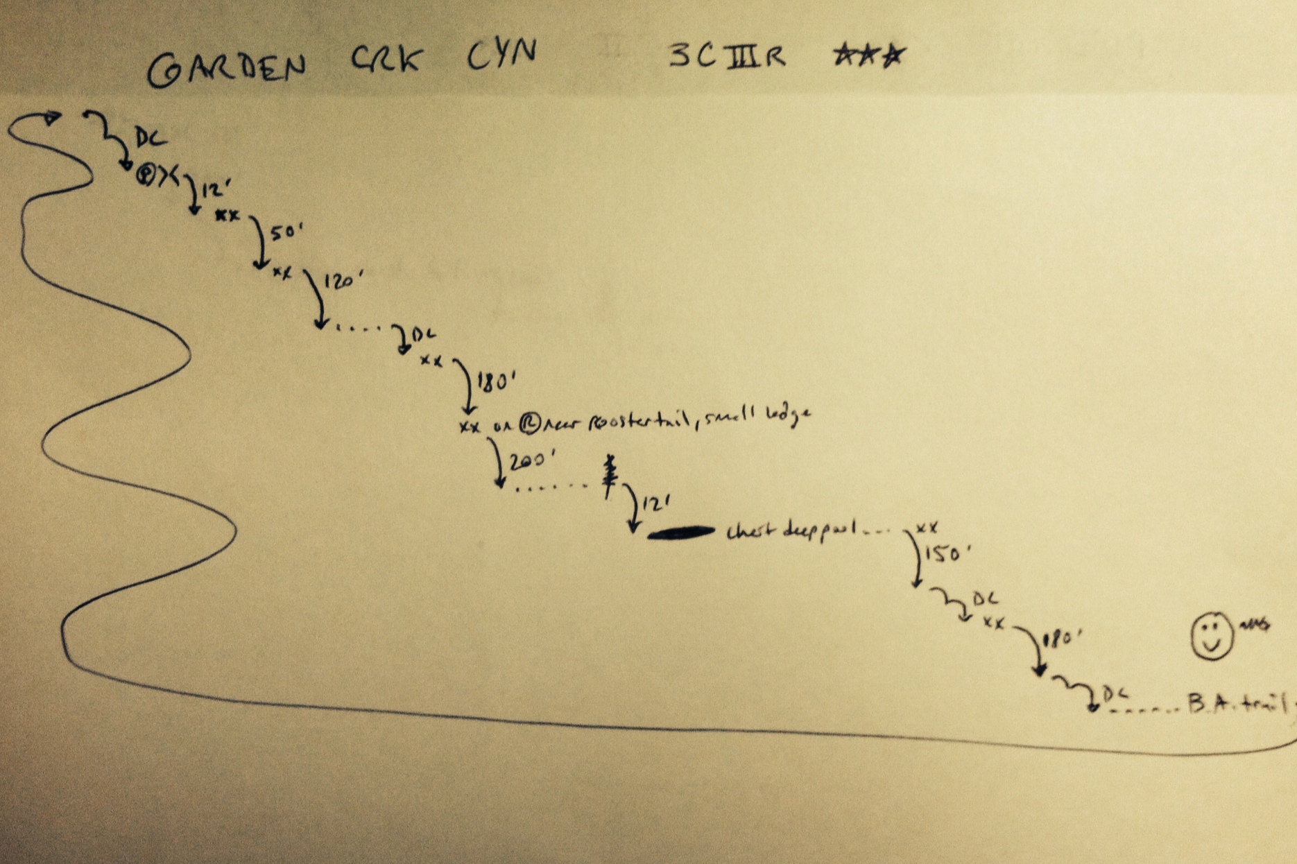
Canyoneering
Consensus
View 6
Grade3
WaterC
Risk
TimeIV
Statistics
tap row or icons for details
Distance Round Trip 13.5 miles
Trailhead Elevation 6,841 feet
Elevation Gain 4,500 feet
Kokopelli Seeds 36
 Interest Off-Trail Hiking, Perennial Waterfall & Perennial Creek
unreported if dogs are allowed
editedit > ops > dogs to adjust
Photos Viewed All MineFollowing
7  2021-09-25 RedwallNHops
2  2015-04-10 markguycan
68  2014-11-26
Thanksgiving Grand Canyoneering
GrottoGirl
7  2014-10-18 nonot
13  2014-09-13 azflyguy
31  2012-11-26
Bright Angel Trail
Dave1
38  2011-10-02 Vaporman
Author
author avatar Guides 16,843
Routes 17,472
Photos 24
Trips 1 map ( 6 miles )
Age 28 Male Gender
Location HAZ, TrailDEX
Historical Weather
Trailhead Forecast
Expand Map
Preferred Jun, Jul, Aug, Sep
Sun  6:06am - 6:46pm
0 Route
 
1 Alternative


remove free decal offer

  Likely In-Season!
Guide Needed
Publish Full Detail Guide


Use +Add above to share photos and triplogs
Overview
Hidden gem right off of the Bright Angel trail with a few big waterfalls up to 400ft, half a dozen rappels, and loads of slippery slides & down climbs. Bring three 200ft ropes or a 350ft rope and enough rope to pull it down...


  • guide related image
    guide related
  • Grand Canyon Use Area Boundaries - Dynamic Map


Check out the Triplogs.
Leave No Trace and +Add a Triplog after your canyon trip to support this local community.
WARNING! Hiking and outdoor related sports can be dangerous. Be responsible and prepare for the trip. Study the area you are entering and plan accordingly. Dress for the current and unexpected weather changes. Take plenty of water. Never go alone. Make an itinerary with your plan(s), route(s), destination(s) and expected return time. Give your itinerary to trusted family and/or friends.

 Permit $$
NPS

Grand Canyon National Park
Details for each are occasionaly below numerous alerts
Entrance Fee
Overnight/Backpacking Permits
Grand Canyon Use Areas Map
Rim-to-Rim and Extended Day Hike/Run


 Directions
or
 Road
Paved - Car Okay

To Bright Angel Trailhead
From Flagstaff head west on I-40 for 30.4 mi to SR-64. Turn right/north and follow SR-64 55 miles to the park. You will receive a map & information at the GC park entrance.

The Bright Angel trailhead is located just west of Kolb Studio in Grand Canyon Village on the South Rim. It is within easy walking distance from Maswik Lodge, Bright Angel Lodge, rim lodge parking areas and from Parking Lots E and D. Out of consideration for daytime park visitors, it is recommended that overnight hikers park at Parking Lot E (the Backcountry Information Center parking lot). Though this is not the closest parking area, it is the most secure and is also where the largest number of parking spaces are located.

From PHX (I-10 & AZ-51) 234 mi - about 3 hours 43 mins
From TUC (Jct 1-10 & Grant) 339 mi - about 5 hours 13 mins
From FLG (Jct I-17 & I-40) 87.2 mi - about 1 hour 34 mins
page created by Vaporman on Oct 11 2011 9:57 pm
 90+° 8am - 6pm kills
helpcorrectionissue

end of page marker