|
tap row or icons for details
|
| Distance One Way |
|
0 miles |
| Trailhead Elevation |
|
699 feet |
| Interest Historic, Seasonal Creek & Peak | |
| | |
|
|
15 |
2011-12-23 | azbackpackr |
|
| |
|
|
list |
map |
done |
San Diego Region |
| | |
|
| |
|
|
Historical Weather |
| Trailhead Forecast | | |
|
 |
|
|
| Preferred Jan, Feb, Dec, Mar |
|
|
| | |
| |
Named Locations Coordinate Links
| |
|
| help future hikers |
| post a gps route now |
| | |
| |
|
|
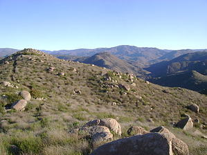
 Overview: Overview: A hike in chaparral at the head of San Pascual Valley, with long views of mountains and the valley, with a view of the ocean on a clear day. Across the highway to the east a short distance there is also a trailhead for North Clevenger Canyon Trails. All of this is part of the San Dieguito River Trail System. Santa Ysabel Creek runs alongside highway 78, but is not part of the South Clevenger section. If you hike all the trails on south side you will get 7 miles and 1900 feet elevation gain.
One-Way NoticeThis hike is listed as One-Way. When hiking several trails on a single "hike", log it with a generic name that describes the hike. Then link the trails traveled, check out the example. |
 Route Editor


