History:
 Wanted, young, skinny, wiry fellows, not over 18. Must be expert riders, willing to risk death daily. Orphans preferred. That was an actual newspaper ad as business men fought over government contracts for the best method to get messages across this vast nation prior to the civil war. For only nineteen months a brave group of riders, station attendants and blacksmiths moved the mail from St Louis to Sacramento, California in 12 - 14 days. They were replaced by the transcontinental telegraph which could send messages in minutes. To do this they needed to change horses every ten miles. That is as far as a horse could run at a full gallop. The rider would sit on a mochila, which is Spanish for pouch and loaded, it weighed no more than 20 lbs. History buffs refer to the era as the legend of the pony. The station houses were not designed to last and most did not a have a roof.
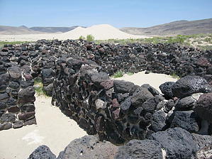
Overview: In 1976, one of these pony station houses was located near sand mountain which is 20 miles east of Fallon, Nevada. Sand mountain sits at the end of a valley and over the last 4,000 years has accumulated a mountain of sand 500 feet tall. The old station house had been buried by sand and well preserved. The BLM and archeologists excavated the site. The building and surrounding desert study area are the object of this hike.
Hike: The trailhead offers no facilities so bring your own. The trail starts out obvious but the shifting sands will keep you alert as route finding becomes an issue. There is no sign of a building, just sand and scrub and in the distance white salt flats. The temperatures are extreme here. Ironically the water table is close to the surface. The trail takes you by an original hand dug well from the pony days. The water is so full of alkali it will leave chemical burns on your hands. To drink it they had to add vinegar to dilute the effects of the alkali. Yet there are plenty of flowers here in the springtime. A collection of typical desert animals also exits. You may encounter snakes, jack rabbits, lizards, rodents, and perhaps a fox. The trail meanders around with little elevation gain. Placards mark the trail so look ahead for where the trail goes. Eventually you see the black stones from surrounding hillsides that were used in the construction of the station. It was stabilized by the archaeologists in 1977. While you have total access and are encouraged to enter all the rooms, stay off the walls. The sand keeps trying to overtake the structure and needs maintenance on a regular basis. Complete the loop by proceeding along the trail which will bring you back to your vehicle. The station is on the Pony Express National Historic Trail and the station house on the National Register of Historic Places.
 Route Editor