 Route Editor

| Guide | ♦ | 2 Triplogs | 0 Topics |
details | drive | permit | forecast | route |
stats |
photos | triplogs | topics | location |
| 18 | 2 | 0 |
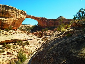
Hike the road into history by PaleoRob  Warning: The trail is generally shadeless for its length, though juniper and pinon do line the old roadway. The trail into the canyon from the rim is old, and can be hard to find if you are not paying attention.
Despite National Monument status, Natural Bridges didn't see much traffic. In fact it wasn't until 1939 that the monument saw over 1,00 visitors (up from 20 in 1923). It was during this quiet period of time, starting in 1916, that Zeke Johnson ran Natural Bridges. Born in 1869 in Bellvue, Utah to a polygamist family, Zeke was always a wilderness man. He ran cattle on the Navajo Nation and on the Arizona Strip. He became a guide on the high plateaus above the San Juan, leading adventurous Anglos to deep canyons and towering cliffs. It was during his guide years that he developed a love for the Natural Bridges area. When it came time to appoint a ranger (only 8 years after the monument was created!), Zeke was the obvious choice - no one knew the White Canyon wilderness better. One of Zeke's first tasks was to make the monument more accessible. To accomplish this, he built a road from the then-unpaved UT Route 95 to the rim of Armstrong Canyon, just across from Owachomo Bridge. This was the main entrance to the monument until the realignment of UT-95 between 1962-66. This realignment paved portions of the road, bridged the Colorado River, and added the spur road to Natural Bridges that serves as the primary access point today. When you are at the canyon rim, look around for remains of the old ranger's residence (now just some rough-hewn logs, concrete chunks, and broken glass), as well as old cans and other refuse left over from earlier visitors. Hike: From the "parking" area near UT-95, follow the closed road for about 1.75 miles to the rim of Armstrong Canyon. About half way to the rim, you'll encounter a fence - this is the monument boundary. Step over or shimmy under - the choice is yours. The old road hits the rim and makes a sharp left. This is your first glimpse of Owachomo Bridge. Follow the road down to the left. It switchbacks across a dry wash. You can see the road hasn't been driven for a while, as it is washed out here. Old pipes stick out of the bedrock, a reminder of what used to hold the roadbed in place. After recrossing the wash, the road disappears into a patch of mounded slickrock. This is the old ranger's residence/park HQ. You can explore here if you wish. To get down into the canyon, head towards the rim and look for the concrete blocks with bolts stuck in them. This marks the start of the old hiking trail. It heads down to the right from this point, then switchbacks, dropping you on another slickrock bench, with a dead juniper between you and the bridge. A constructed trail heads in both directions - to get to the bottom of the bridge you want to head left. The old trail hugs the cliffs then switchbacks down. There is a short section of constructed stairs, then you are on the supported ramp that leads to the slickrock at the bottom of the canyon. Congratulations - you've made it! Either return to the trailhead the way you came, or pick up your shuttle vehicle that you left waiting at the Owachomo Bridge trailhead. Water Sources: Occasional pool/stream in Armstrong Canyon. The pool at the junction of Armstrong and Tuwa is usually present even on hot June days. Don't count on it, though - when you need it the most, it won't be there. Check out the Official Route and Triplogs. Leave No Trace and +Add a Triplog after your hike to support this local community. One-Way Notice This hike is listed as One-Way. When hiking several trails on a single "hike", log it with a generic name that describes the hike. Then link the trails traveled, check out the example. | ||||||||||||||||||||||||||||||||||||||||||||||||||||||||||||||||||||||||||||||||||||||||


