 Route Editor

| Guide | ♦ | 80 Triplogs | 0 Topics |
details | drive | permit | forecast | route |
stats |
photos | triplogs | topics | location |
| 290 | 80 | 0 |
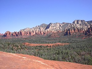
Slick Rock by Trishness   I can't imagine a better hike in the area just south of Sedona. This has spectacular red rock views to the west and white/red rock views to the east as it leads you through some pristine areas of Pinyon pine, juniper, and Arizona Cypress. Slick rock areas are prominent throughout this hike, which adds to the area's overall beauty. I can't imagine a better hike in the area just south of Sedona. This has spectacular red rock views to the west and white/red rock views to the east as it leads you through some pristine areas of Pinyon pine, juniper, and Arizona Cypress. Slick rock areas are prominent throughout this hike, which adds to the area's overall beauty.The trailhead is easily accessible at the end of Morgan Road. There is one 0.25 area of dirt/Jeep road that I did easily in my little Ford Focus. There is plenty of parking, but a Red Rock Pass is required. The trailhead is located just across the jeep road, and it is easily accessed, wide, and well-marked. The slickrock areas are very well marked by cairns. I left the TH at 9:30 AM on a gorgeous October morning with no clouds in the sky. As you leave the trailhead, you already have visions of what to expect, the white & red limestone formations of Mund's Mountain Wilderness to your east and the red rocks of Battlement Mesa & Twin Buttes to your west. The trail was wide and easy to follow through Pinyon pines & cypress and followed the terrain. There is supposed to be a trail to the saddle on Battlement Mesa, but I couldn't find it, so I continued on the defined trail, which gently followed the terrain.
As I was sitting up on that slick rock, I saw Submarine Rock and thought it would be cool to visit that on the way back. So, I started back, and when I got to the well-marked junction, I took the low road. Another good decision. This little side trip took me to the bottom of the canyon on a very easy, wooded trail, across a slick rock area dotted with black volcanic rock & red rock, crossing one Jeep trail and one wash, and was only 2 miles roundtrip. The view from the floor of the canyon was gorgeous. Of course, once I was at the base of Submarine Rock, I just had to climb it! There is no defined trail to the top, but it is all slick rock on the way up. I climbed up and made it to the top, where I explored for a while, then headed back down and out to hook back up with the trail. After ascending the canyon and getting back onto Broken Arrow, I searched AGAIN for the trail to Battlement Mesa but couldn't find it. I loved this hike. The views throughout were fantastic. You can take this past Chicken Point and hike down Little Horse, but that adds another 1.6 miles.
Check out the Official Route and Triplogs. Leave No Trace and +Add a Triplog after your hike to support this local community. One-Way Notice This hike is listed as One-Way. When hiking several trails on a single "hike", log it with a generic name that describes the hike. Then link the trails traveled, check out the example. | |||||||||||||||||||||||||||||||||||||||||||||||||||||||||||||||||||||||||||||||||||||||||||||||||||||||||||||||||||||||||||||||||||||||||||||||||||||||||||||||||||||||||||||||||||||||||||||||||


