Wolf Creek Loop Trail #384 is a scenic loop route among the pines, oaks, and granite boulders, and can be traveled either clockwise, or counter-clockwise from the trailhead. Maverick Mountain and Mount Tritle provide a beautiful backdrop to this trail that winds through lush, riparian vegetation along the Hassayampa River’s upper basin.
This trail can be used year-round. It is rated as "easy," with elevations ranging between 5,710' and 5,670'.
There are about 5 roads that are popular with motorized recreationists that share the same route as the trail. This trail is well used, evident from loose rocks and trail erosion in places.
When hiking several trails on a single "hike", log it with a generic name that describes the hike. Then link the trails traveled, check out the example.
WARNING! Hiking and outdoor related sports can be dangerous. Be responsible and prepare for the trip. Study the area you are entering and plan accordingly. Dress for the current and unexpected weather changes. Take plenty of water. Never go alone. Make an itinerary with your plan(s), route(s), destination(s) and expected return time. Give your itinerary to trusted family and/or friends.
Only trailheads with six "amenities" have fees. Amenities are picnic tables, trash, toilet, parking, interpretive signing and security.
Directions
Road
To Wolf Creek Trailhead To access the trail from Prescott, travel south on Mount Vernon Avenue which changes to Senator Highway, then Forest Road 52, for approximately 6 miles to Groom Creek. Continue past Groom Creek to just beyond where the pavement ends. Turn right on Wolf Creek Road ( FS97 / County Road 101 ). Follow Wolf Creek Road 1.6 miles to a small loop trailhead on the right.
From PHX (I-10 & AZ-51) 2 h 5 min (113 miles) From TUC (Jct 1-10 & Grant) 3 h 27 min (218 miles) From FLG (Jct I-17 & I-40) 1 h 54 min (102 miles)
 Route Editor


 Wolf Creek Loop Trail #384 is a scenic loop route among the pines, oaks, and granite boulders, and can be traveled either clockwise, or counter-clockwise from the trailhead. Maverick Mountain and Mount Tritle provide a beautiful backdrop to this trail that winds through lush, riparian vegetation along the Hassayampa River’s upper basin.
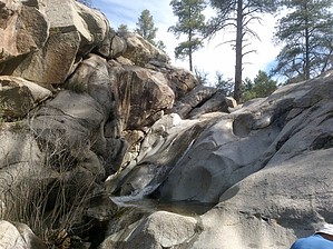


