username
X
password
register
for free!
help
 This is likely a great time to hike this trail!  Check out "Preferred" months below, keep in mind this is an estimate.
  🔥

East Webber Trail #289, AZ

Guide 31 Triplogs  1 Topic
  3.5 of 5  
Fav
Wish
0
details
drive
no permit
forecast
🔥
route  
stats
photos
triplogs
topic
location
336 31 1
Statistics
tap row or icons for details
Difficulty 3.5 of 5
Route Finding 4 of 5
Distance One Way 2.04 miles
Trailhead Elevation 5,747 feet
Elevation Gain 890 feet
Accumulated Gain 911 feet
Kokopelli Seeds 5.08
feature photo
Photos Viewed All MineFollowing
Will recalculate on button tap!
4  2024-06-13
East Webber via Geronimo
fricknaley
16  2023-10-18
Geronimo Trail #240
kingsnake
27  2022-08-06
East Webber Loop
chumley
16  2022-08-04
East Webber Creek
markthurman53
30  2020-05-27
Rim View Webber Loop
outdoor_lover
3  2019-06-08 ShatteredArm
14  2017-05-20
Highline - Rim View Fail - Webber - Donahue
The_Eagle
10  2015-05-22
Highline - AZT #26
nonot
Page 1,  2,  3
Author
author avatar Guides 16,843
Routes 17,472
Photos 24
Trips 1 map ( 6 miles )
Age 28 Male Gender
Location HAZ, TrailDEX
Associated Areas
list map done
Payson Region
Historical Weather
Trailhead Forecast
Radar Map
Expand Map
Preferred Oct, Apr, May, Sep
Sun  6:04am - 6:41pm
Official Route & 1 Rt
 
18 Alternative
 
Historic Fire Perimetersacres
🔥 2019 Coldwater Fire16.8k
🔥 2006 February Fire4.3k
🔥 2006 February14.5 mi*
🔥 2004 Webber Fire4.3k
🔥 2004 Webber14.7 mi*
🔥 View (All) - over Official Route 🔥
*perimeter length in miles


remove free decal offer

 Likely In-Season!
Guide Needed
Publish Full Detail Guide


Use +Add above to share photos and triplogs
The trail crosses Webber Creek 7 times. The entire length has plenty of shade. Near trails end (directly across the creek) is a spring flowing out of a hole at the base of the Mogollon Rim. There are large flat rocks in the creek for play and relaxation.
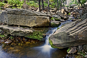


    Check out the Official Route and Triplogs.
    Leave No Trace and +Add a Triplog after your hike to support this local community.

    One-Way Notice
    This hike is listed as One-Way.

    When hiking several trails on a single "hike", log it with a generic name that describes the hike. Then link the trails traveled, check out the example.
    WARNING! Hiking and outdoor related sports can be dangerous. Be responsible and prepare for the trip. Study the area you are entering and plan accordingly. Dress for the current and unexpected weather changes. Take plenty of water. Never go alone. Make an itinerary with your plan(s), route(s), destination(s) and expected return time. Give your itinerary to trusted family and/or friends.

     Permit $$
    no fees or permits reported

    if incorrect tell us about it


     Directions
    or
     Road


    To hike
    page created by joebartels on Nov 25 2012 1:36 pm
     90+° 8am - 6pm kills
    helpcorrectionissue

    end of page marker