 Route Editor

| Guide | ♦ | 5 Triplogs | 1 Topic |
details | drive | permit | forecast | 🔥 route |
stats |
photos | triplogs | topic | location |
| 125 | 5 | 1 |
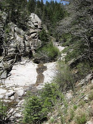
Finest of the Tularosa Basin by Jim The trail begins at the end of Three Rivers Road just beyond the regular campground. Passing by the group campground, you cross the creek and start up hill through some oak and juniper and then come back to hiking along the creek itself. Initially in ponderosa pine, you pick up Douglas-Fir and White Fir pretty quickly. Higher up, some of these trees are very impressive in size. The forest cover affords a great deal of shade. That and the smell of mixed conifers on a warm spring day is one of the great pleasures of this hike. Numerous creek crossing further in provide spots to filter water if you don't want to carry, and while there is the risk of the creek drying out, locals inform me that it never does.
If you take this trail to it's end at the crest trail, but had no plans to continue on, you can rest at the saddle and enjoy some pretty remarkable views, or round out the hike with a short trip to the northwest and Whitehorse Hill, which is 10,255'. You can take the Crest trail to Ski Apache, or make other loops using some other local trails. Please note that trail stats reflect the new guideline of one way statistics for a "trail". If you choose to connect to other trails, your hike will vary accordingly and your data should reflect this. If you choose to hike a round trip Whitehorse Hill Hike (my logical hike to a peak using this trail) it is about 12 & 1/2 miles and 3,800' round trip. Other options in the area exist. Check out the Official Route and Triplogs. Leave No Trace and +Add a Triplog after your hike to support this local community. One-Way Notice This hike is listed as One-Way. When hiking several trails on a single "hike", log it with a generic name that describes the hike. Then link the trails traveled, check out the example. | ||||||||||||||||||||||||||||||||||||||||||||||||||||||||||||||||||||||||||||||||||||||||||||||||||||||


