Route Editor

| Guide | ♦ | 2 Triplogs | 0 Topics |
details | drive | permit | forecast | map |
stats |
photos | triplogs | topics | location |
| 10 | 2 | 0 |
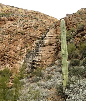
Canyons are inherently risky. Flash floods occur without notice on sunny days. Technical skills & surrounding topography knowledge required yet does not eliminate risk.
It is not stupid by azflyguy  3AII Technical canyon North East of Mormon Flat Dam just behind the "Dam Ahead" floating barrier. Contains 5-7 rappels with a final rappel of ~180'. The shortest packraft launch to the canyon is the closed maintenance road just before the one-way bridge over Canyon Lake. Park on side of AZ88 near the gate but not in front of it or you might get towed. The one-way distance from this spot to the canyon is one mile. You could also launch from the Acadia Recreation site and have a 1.3-mile each-way packraft. However, if the lake has a lot of traffic it might be a little dangerous crossing the lake from this launching location. Carefully find a spot near the floating barrier to get out. Lots of cactus and other sharp things to pop your raft. Deflate and hide your packraft or carefully stash it inflated. Not likely a boater would get out and steal it but I did hear a boat stop to check ours out. Take the only obvious approach just east of the canyon. East side finger of Dam Canyon main at 2,200' contains two rappels. 4-5 rappels in Dam Canyon main below 2,000'. Could also drop into Dam Canyon main drainage past the east finger. Appeared to have a very short narrow section with at least one short rappel. I did not explore that section of the main drainage. All natural anchors please keep it that way. Make sure to check out the next rappel before pulling rope as farming rocks might be required. All water in the canyon should be able to be avoided. 3AII Technical canyon North East of Mormon Flat Dam just behind the "Dam Ahead" floating barrier. Contains 5-7 rappels with a final rappel of ~180'. The shortest packraft launch to the canyon is the closed maintenance road just before the one-way bridge over Canyon Lake. Park on side of AZ88 near the gate but not in front of it or you might get towed. The one-way distance from this spot to the canyon is one mile. You could also launch from the Acadia Recreation site and have a 1.3-mile each-way packraft. However, if the lake has a lot of traffic it might be a little dangerous crossing the lake from this launching location. Carefully find a spot near the floating barrier to get out. Lots of cactus and other sharp things to pop your raft. Deflate and hide your packraft or carefully stash it inflated. Not likely a boater would get out and steal it but I did hear a boat stop to check ours out. Take the only obvious approach just east of the canyon. East side finger of Dam Canyon main at 2,200' contains two rappels. 4-5 rappels in Dam Canyon main below 2,000'. Could also drop into Dam Canyon main drainage past the east finger. Appeared to have a very short narrow section with at least one short rappel. I did not explore that section of the main drainage. All natural anchors please keep it that way. Make sure to check out the next rappel before pulling rope as farming rocks might be required. All water in the canyon should be able to be avoided.Gate Policy: If a gate is closed upon arrival, leave it closed after you go through. If it is open, leave it open. Leaving a closed gate open may put cattle in danger. Closing an open gate may cut them off from water. Please be respectful, leave gates as found. The exception is signage on the gate directing you otherwise. Check out the Triplogs. Leave No Trace and +Add a Triplog after your canyon trip to support this local community. | |||||||||||||||||||||||||||||||||||||||||||||||||||||||||||||||||||||||||||||||||||||||