Route Editor

| Guide | ♦ | 44 Triplogs | 0 Topics |
details | drive | no permit | forecast | 🔥 route |
stats |
photos | triplogs | topics | location |
| 487 | 44 | 0 |
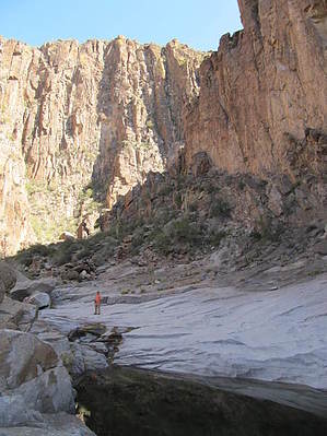
You gotta enjoy boulders by bensondk  Prologue PrologueThis loop hike resulted from wanting to find a shorter version of a hike that would start at the Canyon Lake parking lot, go up La Barge Creek, and return on Boulder Creek. This made for a 10.2-mile day hike suitable for our age 55+ advanced hikers. Fritzski La Barge Lower - Box Loop seeded part of the plan. Be sure to read Fritzski's description for the route's common part, as I have not tried to repeat what he said very well. The key was finding a route across the saddle behind Battleship Mountain to go from La Barge Creek over to Boulder Creek. After seeing the high canyon walls in La Barge Canyon, we knew that had to be a part of the route. Hike The hike starts from the parking lot for the Canyon Lake Marina and crosses the highway to pick up a trail with a big sign marked as the Boulder Canyon Trail. The trail's first leg rises to provide great views of Battleship Mountain ahead and Canyon Lake looking back. Once over the hill, the trail descends into La Barge Creek, where you either follow the creek or the trail to the right of the creek for about 1/4 mile before meeting another trail to the right. This trail to the right goes to Boulder Creek and passes by an old mine. This would be an option either at this stage or as you pass the same trail from the Boulder Creek side. As you make your way up La Barge creek, you come to a point where the canyon walls start to become much higher. Although you will be returning to this point, the hike's highlight is found as you follow the creek to the left for a few hundred feet, then to the right. This will likely be as far as you can go unless you are more seriously into canyoneering. Here the walls of the canyon are very high and provide an incredible sight. Pools of water in the worn rock of the creek bed add to the beauty. Minnows have been seen in the pools. I have found that photos are not able to capture the majestic view of the walls. Depending on your timing, we found this to be an excellent place to plan your lunch break.
As you go over the saddle, you will have a view of the route up to the top of Battleship. On the day we hiked, we were lucky enough to see a group of hikers making their way up to the summit of Battleship. Should you decide to include Battleship summit, beware that it would make for a very long day. It did appear that the summit could be approached from the saddle, but we were not prepared to increase the length of the hike, a decision that proved to be very wise. Once you reach Boulder Creek, turn right to go down the creek. The path will take you in and out of the creek bed and often be marked with helpful cairns. As you work your way down the creek, at N33 20.211 W111 24.300, you will come to the same trail mentioned earlier that crosses over to La Barge Creek. This would have given us the option to go back on the same route as we came in. Instead, we chose to continue down Boulder Creek to reconnect with the inbound trail about half a mile from the trailhead. Boulder Creek is not for everyone but easy if you don't mind hopping from boulder to boulder for much of the way. Once or twice, you may need to use your hands to work through more difficult spots, but none with any exposure. This hike was a learning experience for many members of our group, as it turned out to be a warmer day than usual, and some in the group did not take enough water. As water was shared, others ran out of water, and by the end, there was very little water remaining, with most totally out of water, despite rationing for the last quarter of the hike. We found this hike takes more energy than most 10-mile hikes, so be sure to go prepared. Because water became a higher priority than GPS batteries, my GPS track had to have the last mile patched in from another hike, and as a result, the data is incongruent, so times have been lost uploading to HAZ. If I can hike this trail again, I will update the track with a fresh one complete with all data. Check out the Official Route and Triplogs. Leave No Trace and +Add a Triplog after your hike to support this local community. | ||||||||||||||||||||||||||||||||||||||||||||||||||||||||||||||||||||||||||||||||||||||||||||||||||||||||||||||||||||||||||||||||||||||||||||||||||||||||||||||||||||||||||||||||||||||||||||||||||||||