username
X
password
register
for free!
help
 This is likely a great time to hike this trail!  Check out "Preferred" months below, keep in mind this is an estimate.
  🔥

Vineyard Mountain 3458, AZ

Guide 4 Triplogs  0 Topics
  5 of 5  
Fav
Wish
0
details
drive
no permit
forecast
🔥
route  
stats
photos
triplogs
topics
location
68 4 0
Statistics
tap row or icons for details
Difficulty 2 of 5
Route Finding 2 of 5
Distance Round Trip 4.4 miles
Trailhead Elevation 3,450 feet
Elevation Gain 1,234 feet
Accumulated Gain 1,272 feet
Avg Time Round Trip 3 hours
Kokopelli Seeds 10.76
 Backpack Yes & Connecting
unreported if dogs are allowed
editedit > ops > dogs to adjust
feature photo
Photos Viewed All MineFollowing
Will recalculate on button tap!
41  2025-10-17 Mike_W
27  2013-02-14
Camelback Peak 5663
BobP
Author
author avatar Guides 105
Routes 260
Photos 16,440
Trips 541 map ( 2,914 miles )
Age Male Gender
Location Tucson, AZ
Associated Areas
list map done
Payson Region
Historical Weather
Trailhead Forecast
Radar Map
Expand Map
Preferred Oct, Nov, Mar, Apr → 9 AM
Seasons   Early Autumn to Late Spring
Sun  6:37am - 5:41pm
Official Route
 
0 Alternative
 
Historic Fire Perimetersacres
🔥 2020 Bush Fire193.5k
🔥 2019 Woodbury Fire123.8k
🔥 View (All) - over Official Route 🔥


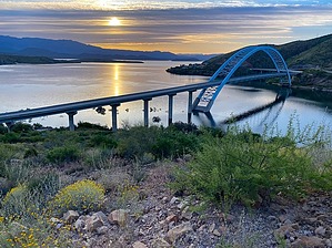
No grapes or wine seen the entire way!
by Mike_W

 Likely In-Season!
Expand MapOverview
Vineyard Mountain, at an elevation of 3,458 feet, is a great scenic hike south of Theodore Roosevelt Lake and is near the small town of Roosevelt. Much of the hike to Vineyard Mountain follows the Arizona Trail. There are great views of the lake for the first mile or more. The final 1/4 mile of the hike is an open country walk up to the high point.


Hike
To get to the AZ Trail / Vineyard Trail from the parking area, you need to cross the road and walk to the left behind the guard rail. Then, you will see a sign up ahead.
remove free decal offer
The trail starts climbing up, and for the first 1/4 mile, you will have excellent views of the Roosevelt Lake bridge and the lake. The views of the lake will continue for roughly the first mile of the trail.

The trail was maintained very well the entire way; however, it was quite rocky in many places. For the first 1/2 mile, there were a few switchbacks. After this, the trail continues up and goes around a place called Inspiration Point. Once you get around Inspiration Point, you will climb a steep trail and arrive at a small saddle. From the saddle, Inspiration Point will block part of the view of the lake. It is possible to climb to the top of Inspiration Point, but that is not necessary, as the views are incredible from many locations.

After the saddle, the trail continues up the ridgeline. Up ahead, there was a huge structure that looked like some kind of antenna. The top was a square grid of white panels, maybe 20 feet by 20 feet, and the panels were maybe 30 feet off the ground.

From the tall structure, it's about another 0.25 mile of trail to get to the point where you should go off-trail to summit Vineyard Mountain. Then, once off-trail, it's another 0.25-mile open country hike to the high point. There are some rocks and a small amount of brush to go around, but it's easy enough to walk almost directly to the high point. At the high point, you should find a registry.

You could walk a few hundred feet from the high point, slightly down toward the Salt River, to get some nice photos. Take the same route back down to the parking area.

2025-10-21 Mike_W


    Check out the Official Route and Triplogs.
    Leave No Trace and +Add a Triplog after your hike to support this local community.
    WARNING! Hiking and outdoor related sports can be dangerous. Be responsible and prepare for the trip. Study the area you are entering and plan accordingly. Dress for the current and unexpected weather changes. Take plenty of water. Never go alone. Make an itinerary with your plan(s), route(s), destination(s) and expected return time. Give your itinerary to trusted family and/or friends.

     Permit $$
    None


     Directions
    or
     Road
    Paved - Car Okay

    To hike
    Note: Trailhead is accessible by a standard sedan. All paved to the trailhead!

    You may be able to set Google Maps to
    Vineyard Trailhead
    29221 AZ-188, Roosevelt, AZ 85545

    If you can't find that, just follow this...

    From the center of Roosevelt, head West on AZ-188 for 2 miles.
    Just after crossing the Roosevelt Lake bridge, look for signs for the Vineyard trail or the Arizona Trail
    Park in the lot on the right side of the road.
    There's room for probably 20 vehicles.
    page created by BobP on Oct 21 2025 6:06 pm
    helpcorrectionissue

    end of page marker