 Route Editor

| Guide | ♦ | 106 Triplogs | 2 Topics |
details | drive | permit | forecast | route |
stats |
photos | triplogs | topics | location |
| 586 | 106 | 2 |
Saddles, Tanks, and VIEWS!! by Mike   History HistoryMining in Arizona was no problem, but local smelting of the ores called for vast amounts of fuel. Fuel in the Jerome smelters was supplied by timber from Woodchute Mountain. The logs were cut and sent sliding down the mountain via a log chute. The lumber was used for open roasting to remove sulfur from the ores. Between the resultant killing fumes and the unceasing demand for timber, the mountain is now denuded of wood. Later, mines in the mountain caved in. Lack of wood forced the mine owners to find a new location for the smelter. It was built at Clarkdale. Note Trail data is for the complete #102 segment
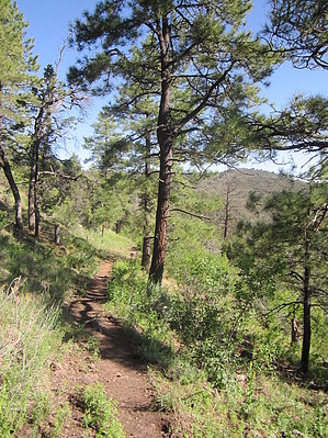
The road here forks in several places, keep to the right, and shortly you will come to the original trailhead. From here, the trail enters the Woodchute Wilderness, and begins to climb gently through the forest around a steep-sided hill. As it passes around to the north side of the hill, highway 89-A will come into view, and for a while, the sounds of the forest will be occasionally drowned out by the roar of traffic. Eventually, you'll pass out of range of the road noise. Meanwhile, the views along this section are worth putting up with the highway for a while. The first of several saddles will be reached offering great views of the Verde Valley and the San Francisco Peaks to the north. To the south are views of Prescott Valley and Granite Mountain. A short, steeper climb will bring you to a higher saddle just east of a small peak, which the trail bypasses to the south. There is a side trail to the right that will take you to the top of the peak. It is well worth the short climb to see the views from there. Beyond the peak, the trail drops to another saddle then begins to travel downhill to the back of a canyon sandwiched by Woodchute Mountain and a smaller mesa. At the back of the canyon, the trail crosses a dry creek bed inhabited by swarms of butterflies. From here a short distance will bring you to Woodchute Tank. This tank was built by a bulldozer, which was also used to build the first part of the trail itself. A side trail passes through a fence and follows by the tank. The main trail stays to the right. Beyond the tank, the trail begins to climb through the meadows along the side of Woodchute Mountain, giving nice views of a small valley cradled by the surrounding mesas. A large alligator juniper signals the top of the mesa. After topping out on the mesa, the trail continues through alternating forest and meadows and after about 1/2 mile, reaches a fork in the trail. The right fork leads to the mesa's edge and great views of Cottonwood,Jerome, Sycamore Canyon, the Sedona area and beyond. Return the way you came in. Oh, and be sure to keep a careful eye out on your return... for those of you who may have wondered whatever happened to the Taco Bell Chihuahua, the mystery has been solved!! Gate Policy: If a gate is closed upon arrival, leave it closed after you go through. If it is open, leave it open. Leaving a closed gate open may put cattle in danger. Closing an open gate may cut them off from water. Please be respectful, leave gates as found. The exception is signage on the gate directing you otherwise.
Prescott FS Details This trail on the south side of Woodchute Mountain was established along what was once a bulldozer track. The bulldozer was used to create several cattle watering tanks on Woodchute Mountain. The top of the mountain is an open stand of second growth Ponderosa pine, the original forest having been completely cut years ago. When the copper mines at Jerome were in operation, loggers obtained shoring timbers for the mines from this mountain. They transported the logs by way of a chute extending down the north side of the mountain to loading platforms for the narrow gauge railroad which served Jerome. That railroad track is now FR 318. There are splendid panoramic views from the mountaintop in all directions. Maps, other resources: Prescott National Forest, east half; U.S.G.S. topographic 7.5' quads for Munds Draw and Hickey Mountain. Trail layout: From the south trailhead it is a fairly easy climb of 2.75 miles to the top of Woodchute Mountain, then another 3.5 miles down the north side to the north trailhead and the old narrow gauge road (FR 318) to Jerome. The south ascent is the easiest since it only climbs 600 ft. to the summit. From the top at 7,700 ft. to the north trailhead the descent is 2,260 ft. There are some steep switchbacks on this side. Precautions: There is no drinking water along this trail. Check out the Official Route and Triplogs. Leave No Trace and +Add a Triplog after your hike to support this local community. One-Way Notice This hike is listed as One-Way. When hiking several trails on a single "hike", log it with a generic name that describes the hike. Then link the trails traveled, check out the example. | |||||||||||||||||||||||||||||||||||||||||||||||||||||||||||||||||||||||||||||||||||||||||||||||||||||||||||||||||||||||||||||||||||||||||||||||||||||||||||||||||||||||||||||||||||||||||||||||||||


