username
X
password
register
for free!
help
  
  🔥

Waterslides Canyon, AZ

Guide 7 Triplogs  2 Topics
  5 of 5  
Fav
Wish
3
details
drive
no permit
forecast
🔥
route  
stats
photos
triplogs
topics
location
19 7 2
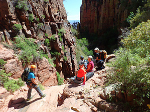
Canyons are inherently risky. Flash floods occur without notice on sunny days. Technical skills & surrounding topography knowledge required yet does not eliminate risk.
Canyoneering
Consensus
View 2
Grade3
WaterB
Risk
TimeIII
Statistics
tap row or icons for details
Distance One Way 3.7 miles
Trailhead Elevation 4,845 feet
Elevation Gain -1,965 feet
Kokopelli Seeds 6.98
 Interest Off-Trail Hiking, Seasonal Waterfall & Seasonal Creek
unreported if dogs are allowed
editedit > ops > dogs to adjust
feature photo
Photos Viewed All MineFollowing
Inaugural Calculation on Button Tap!
18  2021-01-02
Anchas New Year Continued
jillyonanadventu
7  2016-04-17 knmurphy
12  2015-04-17 outdoor_lover
Author
author avatar Guides 16,843
Routes 17,472
Photos 24
Trips 1 map ( 6 miles )
Age 28 Male Gender
Location HAZ, TrailDEX
Historical Weather
Trailhead Forecast
Radar Map
Expand Map
Preferred Feb, Feb, Mar, Apr
Sun  6:03am - 6:38pm
Official Route
 
0 Alternative
 
Historic Fire Perimetersacres
🔥 1980 Cherry Fire2.3k
🔥 1976 Bull Fire4.4k
🔥 1970 Deep Fire2.3k
🔥 View (All) - over Official Route 🔥


remove free decal offer

  
Guide Needed
Publish Full Detail Guide


Use +Add above to share photos and triplogs
Overview
Waterslides Canyon located in the Sierra Ancha's is known for its natural water slides and large pools of water. This canyon with 6 or 7 rappels is best done during the snow melt in the spring when the flow allows for maximum sliding on the natural slides.


    Check out the Official Route and Triplogs.
    Leave No Trace and +Add a Triplog after your canyon trip to support this local community.
    WARNING! Hiking and outdoor related sports can be dangerous. Be responsible and prepare for the trip. Study the area you are entering and plan accordingly. Dress for the current and unexpected weather changes. Take plenty of water. Never go alone. Make an itinerary with your plan(s), route(s), destination(s) and expected return time. Give your itinerary to trusted family and/or friends.

     Permit $$
    None


     Directions
    or
     Road
    High Clearance possible when dry

    To canyon trip
    From AZ Hwy 288, take Cherry Creek Road approximately 15.7 miles and park a vehicle at the exit of the canyon along Cherry Creek. The entry to the canyon is along NF-203A approximately 14.8 miles from the intersection of AZ Hwy 288 and Cherry Creek Road.
    page created by azmike on Apr 15 2013 1:57 am
     90+° 8am - 6pm kills
    helpcorrectionissue

    end of page marker