 Route Editor

| Guide | ♦ | 411 Triplogs | 20 Topics |
details | drive | no permit | forecast | 🔥 route |
stats |
photos | triplogs | topics | location |
| 2.8k | 411 | 20 |
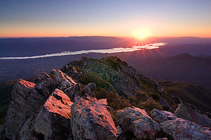
Best 360 View in AZ! by joebartels   Origin of HAZ Origin of HAZThe Four Peaks, more specifically Brown's Peak and the uncontrollable desire to reach the summit! On a warm day in mid-February 1997, my hiking adventures began. Looking back, I can hardly imagine a more enjoyable experience. Having lived in the Valley of the Sun for over ten years, one day I just decided I was going to take a closer look at those mountains jutting up to the east. Glad I did. To this day, even the mention of the Four Peaks gets my full attention. Research So I decided to go to the library and see what I could find out about these mountains to the valley's east. I checked out all the maps and quickly figured out what I was looking at was called the Four Peaks. Funny because I'd heard the name at least a dozen times in the past, but it never really set in. Now that I think about it, I recall several winters when folks would point over to the east from the valley and mention the snow-covered peaks. I did find it interesting that a guy could be standing in the middle of the desert, looking over at snow on a mountain. My honest thought was that those mountains must be a long way away, like maybe the border of New Mexico. Boy, I was wrong. The Four Peaks are the southern terminus of the Mazatzal Mountains. This section is an extreme rise of jagged rock. Starting at 2,000 feet on the desert floor and jutting up to 7,657 feet at the very top of Brown's Peak, which is the northernmost peak.
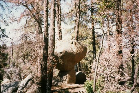
Heading out in my trusty Ford Escort I attempt to reach Lone Pine Saddle. This is the parking area for the Brown's Trail #133, Four Peaks Trail #130, and eventually Amethyst Trail #253. The unpaved forest road #143 is the only logical route to the saddle from the mountain's west side. This forest road is easily identified from State Highway 87 just 21 miles north of Mesa. My first attempt proved I was not mentally prepared for the twenty-plus-mile stretch up to the saddle. The road is actually in excellent shape for such a remote area. The drive would be more reassuring in a 4WD truck. After a few trips on this road, I have come to appreciate the beauty of the desert. Okay, I never made it all the way up on this route until about a year later. An easier route is to go all the way around to the Roosevelt ake side. El Oso Road is the #143 equivalent on the east side of the mountain. It is about half the distance to the saddle, although much steeper. In my opinion, the road is very passable to any decent running car. It takes about thirty minutes to reach the saddle on this forest road. I usually pass a few grazing cows and an occasional horseback rider. Along the way, you quickly pass through the various vegetation zones as if you were going up an elevator in a science project. Excellent views of Roosevelt lake open up at several points along the way. Upon reaching the Mazatzal divide, turn right (south) and follow the inline forest road #648 to the end, Lone Pine Saddle. The temperature here in midday will be about ten degrees cooler from the desert floor below. I would not recommend the west side 20 mile stretch of forest road #143 to a regular car. I have made it up and down several times. However, there are a few streams to cross when water is present and an extreme rocky section just after Mud Springs that'll rattle your mind at first. Along the way up, you will drive in and out of the scorched areas caused by the Lone Fire in late April 1996. The Lone fire is the result of a careless individual dropping a cigarette at the trailhead of Pigeon Trail #134. Depressing to think about, yet nature is making a remarkable comeback. Many books describe the Four Peaks area as a sky island. I classify this hike as a three-part experience. The first being the drive up to the trailhead. Most folks would be satisfied with the adventure of getting to the trailhead. Second comes the hike from the trailhead to Brown's Saddle. Third is the nail-biting adventure up the scree chute topping out on Browns Peak! The combination of all three will prove to be an exhausting day on your first few attempts. Hike Begin the hike at the well-marked trailhead. You are looking for Browns Trail #133. Beginning as a moderate incline, the well-defined path crosses numerous waterbars. The forest is lush and untouched by the Lone fire in the beginning. After a few switchbacks you will pass Snoopy's friend Woodstock. I doubt this is the official name of the rock, but you will see the resemblance. Shortly after, the green forest gives way to the scorched burn areas. Continue hiking along the trail, and eastern views of the Tonto Basin and Roosevelt Lake open up. This photo was taken one year after the fire. Ground cover was beginning to surface. Two years after the fire, small bushes and thick ground cover is taking over. It will take twenty years for the area to get back to the beautiful forest of trees seen before the fire. Eventually, the trail hooks up with the Amethyst Trail #253. The intersection is nothing to be concerned with, and you will most likely not even know as Browns Trail gives way to the Amethyst Trail. Follow the Amethyst Trail for a short distance up to Brown's Saddle. Take a moment at the saddle to view the Valley of the Sun to the west. Smog usually fills the valley, making it hard to see many landmarks. You can see Camelback, Piestewa Peak, and other small landmarks of the valley on a clear day. As seen in the photo below, even on a smoggy day, the Superstition Wilderness view is awesome. Not many folks get to see the Superstitions from this angle. The ripples of the desert floor are breathtaking! Even on the calmest day of the year, you will feel a breeze on the saddle. This is a good turnaround point for your first attempt. Peak From Brown's Saddle, you can make it to the top of Brown's Peak, which is the highest of the four peaks. The trail heads up from the saddle. If you are traversing the western face of the peaks, you have taken the wrong trail, which is the continuation of Amethyst Trail to the amethyst mine on private property. Hiking up the scrambling undefined trail to Brown's Peak is confusing at first. After a few attempts, you will figure it out. You will hike over boulders. Depending on the route followed, you may have to squeeze through a narrow gap. This is the route I prefer. Just after the squeeze, a ravine opens up. The gorge is steep. Loose rocks make the hike challenging and dangerous. Be careful. Looking up the ravine is the scree chute you are looking to scale to the peak. It appears as if Brown's Peak is right at the top. It is a bit further, just one more jag of trail after the false peak. Let's not get excited just yet. You still have to make it up this chute. Looking at the chute from here, it seems steep, and it is. Be careful, do not attempt this unless you are with a friend and out of your mind! Seriously this is dangerous. I would highly recommend attempting this section only in warm weather. On January 16th, 1998, I had the worse experience in Arizona heading up this crevasse. There were three-foot snowdrifts on top of an inch of solid ice. If you enjoy ice slides, this is the closest you will find near the valley. Okay, you have decided to make the ascent. Move slowly. Be sure you only go up into places you feel comfortable coming down. Remember, it's easier getting up than coming back down. On to the most challenging section, there is a small wall you must scale. Continue up to a tiny saddle. There is more evidence of a trail from here on. You shouldn't have any problems finding your way over the last series of boulders to the top. June through September, you will be greeted by butterflies and ladybugs! A nice change from the scorpions and tarantulas below. This is it! You are standing on the throne of the wilderness. I usually call my dad from the peak as the cell phone signals are strong up here. If you are equipped with a good knowledge of your surrounding area, this is the view you have been waiting for your whole life! You can see as far north as the San Francisco Peaks on a clear day. Humphrey's is the highest peak in Arizona, but I would recommend Brown's Peak any day! Synopsis The scree was the only part that resembled my heart's desire of surfing. That said, this hiking thing might work out. Check out the Official Route and Triplogs. Note This is a moderately difficult hike. Leave No Trace and +Add a Triplog after your hike to support this local community. | |||||||||||||||||||||||||||||||||||||||||||||||||||||||||||||||||||||||||||||||||||||||||||||||||||||||||||||||||||||||||||||||||||||


