Route Editor

| Guide | ♦ | 77 Triplogs | 3 Topics |
details | drive | no permit | forecast | 🔥 route |
stats |
photos | triplogs | topics | location |
| 691 | 77 | 3 |
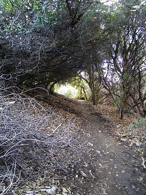
Wilderness Run Around by joebartels  Overview OverviewThe trail data reflects a trip from the Peralta trailhead looping around Bluff Spring Mountain. Route Bluff Spring Trail #235, Dutchman's Trail #104, Terrapin Trail #234, and follow #235 back.
I jumped on the trail at 6:37 am. I must admit I was excited to get in the first real hike of the season. Following the Bluff Springs Trail #235, I breezed up the first section, which I figured to be the most challenging. The original plan was to head out to Charlebois Canyon and find the Peralta Master Map. I missed the rock art on my first venture back in March. Not super exciting, but it's been buggin' me all summer that I came up empty-handed. Carlson ( Hikers Guide to the Superstition Wilderness book ) lists the hike to Charlebois as 7 miles one way. The morning air was refreshing after an extended hot Arizona summer. I passed one older man in the first mile. He couldn't figure out how to reply to "good morning". Approaching the turn up the creek bed before leading into Barks Canyon, I noticed a couple mid-way up Barks. I seriously doubted they planned that route. The turn is confusing, and I still can't figure out why the FS doesn't put up a sign. A bit further on, I noticed the couple heading up a steep wiggly canyon. I guess they were determined to conquer Barks and top out on Weavers Outlook Ridge. 7:39 am I crossed the Terrapin / Bluff junction( new signs! ). The trail up to this point was as expected. The moment I continued on Bluff Springs Trail past the Terrapin junction, things changed. The trail was slightly overgrown. Not usually so bad, but it was all prickly bush. I might add at this point, the battery in my camera was nearly dead. Plus, the backup was completely dead. However, I wasn't too disappointed. There was enough juice to capture the Peralta Master Maps. Besides, I've photographed most of the trail on other hikes. ( see Bluff Spring Loop & Weaver's View ) I turned onto the Dutchman and headed up towards Charlebois Canyon. This was my first time on this section of the Dutchman. Upon reaching Charlebois Canyon, I could finally say I've hiked the entire Dutchman Trail. I realized this on the trail! 9:18 am I passed the Red Tanks / Dutchman junction. The post and signage were knocked over. The terrain up to this point was better than expected. The Dutchman Trail between Bluff Springs Trail and Red Tanks Trail hovers ( on the right ) above a noticeably etched creek bed. It appears there have been some significant currents draining down towards La Barge Canyon. Looking at Topo USA 3D maps, it's easy to see how the water is funneled through the area. Also interesting to note from an overhead 3D view: Bluff Springs Mountain has a valley cut in the middle. It starts high on the SE end and drops down to the NW end. Anyhow heading away from the Red Tank junction, you'll pass near two good-sized cottonwoods in the creek. The sound of the leaves fanning in the breeze almost made me feel cool! After crossing the creek you're following above the creek, which has now switched to your left. There's an ol' hearty orange metal fence post. I'm not sure what its purpose is; the county boundary is a few miles north. The forest and wilderness boundaries are far away too. Best I could make up there's a HUGE century plant across the trail and yard or so up. It's definitely not marking the scraggly ol' dying cholla hugging the post. Unless it's some rare breed... lol. In which case, I'm sad to report the breed is dead. The prickly bush was beginning to take its toll. At the same time, I was nearing Charlebois, so the pace was swift. Passing by the mouth of Music Canyon I was more intrigued. Carlson briefly mentions the canyon as scenic and not a group area. I never gave it much thought. From the books I've read, there's nothing noteworthy in the canyon. However, I did find it inviting. It's tighter and deeper cut than I had previously imagined from reading. Like Charlebois, it has an Oasis feeling. Charlebois Spring is more reliable, and the canyon is bigger for the record. On the Dutchman between Music Canyon and Charlebois: La Barge Canyon is very welcoming. The creek bed twists and turns. It goes from narrow to super-wide. Some of the creek bed is small hopscotch bouldering. Then in an eye's blink, you're crossing pure sand. I'm not sure if the Dutchman Trail is blazed on the sides. I didn't care to look. It did appear to cross back and forth. Basically, I just wandered up towards Charlebois Canyon. The trail picks up on the right and soon intersects with Peters Trail. (9:59 am) I continued. At this point, I figure I'm not a good scout. Carlson says the Peralta Master Map isn't tricky to find. On this, my second trip, I came up empty-handed again. In all honesty, I wasn't very disappointed. It's more of a reason to get out on the trail, and this just meant I'd have a good reason to return! The bad news was my legs were bleeding, and I wasn't looking forward to the return trip. I looked around for a nice stick to help minimize the bush contact. Then I decided I didn't want to go through that crap again. I opted to continue on the Dutchman and circle Bluff Springs Mountain picking up the Terrapin back home. From La Barge up to Marsh Valley is another excellent stretch. Of course, I already knew this from my March 3rd trip. Still full of energy, I continued. The overgrown prickly bush didn't give. I guess it's just like that. I sure don't recall it being so nasty in March. In which case, I highly recommend tight weave jeans and a couple of walking sticks. 10:55 am I passed the Bull Pass / Dutchman junction staying on the Dutchman. The stick was working out pretty good, and the trip was enjoyable until... 11:30 am I came to the NW beginning of the Terrapin Trail. Initially, I was enthusiastic, as I hadn't crossed the upper sections of this trail. It didn't take long for reality to sink in. The Terrapin Trail climbs 700 feet from the junction. No biggy on 2-3 mile hike. Unfortunately, I didn't check the maps very well, and this was a big surprise. I hadn't conserved my water supply for any ascents. I thought it was mostly flat and then downhill. The weatherman lied too... lol The forecasted partly cloudy day was all to the east. Later I found out on the HAZ Forum this was over the Reavis Ranch area, great! Even though I was still full of energy, I decided to slow it down as my water was down to maybe ten ounces. The Terrapin heads mostly straight up to Terrapin Pass. Take the time to turn around. Malapais Mountain is beautiful from Marsh Valley and it's beautiful from here too! I was exhausted. I decided to hold back on the water until after passing the Weavers Needle. I figured, heck, I'd consumed at least 90oz already, and although I was tired, I didn't feel out of it. The Terrapin comes right up to the eastern edge of Weavers. There's a square 4x4 fence post at the best view. No sign in place, but I'm sure it was some warning to be careful venturing off the trail. I took a photo and moved on. From there on, I was crossing the previously mentioned trail, so that about wraps it up. ( read Bluff Spring Loop & Weaver's View for additional info ) The pace back to the trailhead was slow. I took a couple of naps on the rocks to enjoy the storms rolling in. I arrived back at the trailhead at 2:44 pm. I'm happy to report I went nearly 15 miles in tevas without one blister! Eat your heart out, boot troopers! Check out the Official Route and Triplogs. Note This is a moderately difficult hike. Leave No Trace and +Add a Triplog after your hike to support this local community. | ||||||||||||||||||||||||||||||||||||||||||||||||||||||||||||||||||||||||||||||||||||||||||||||||||||||||||||||||||||||||||||||||||||||||||||||||||||||||||||||||||||||||||||||||||||||||||||||||||||||||||||