Route Editor

| Guide | ♦ | 47 Triplogs | 2 Topics |
details | drive | no permit | forecast | 🔥 route |
stats |
photos | triplogs | topics | location |
| 467 | 47 | 2 |
Canyons are inherently risky. Flash floods occur without notice on sunny days. Technical skills & surrounding topography knowledge required yet does not eliminate risk.
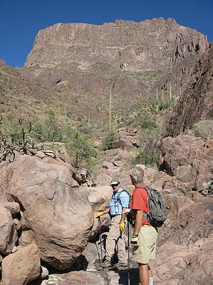
Bushwhacking The Monolith by AZLOT69  Monument Canyon lies at the Southwest corner of the Superstitions directly beneath the southern side of the Flatiron. Human-made monuments are often built to impress or leave you in awe. Monumental refers to something extraordinary in size or power. The massive rock monoliths guarding this canyon stand as a warning. Heed the warning if you are simply looking to stretch your legs. Pay no attention to the distance of this hike. It will certainly take most of the day. Route finding skills will be put to the test. It is a rough, rocky trail followed by a brutal bushwhack with bouldering and canyoneering into an area few others have visited, offering yet another side of the mysterious Superstitions with the hint of some obscure history. Monument Canyon lies at the Southwest corner of the Superstitions directly beneath the southern side of the Flatiron. Human-made monuments are often built to impress or leave you in awe. Monumental refers to something extraordinary in size or power. The massive rock monoliths guarding this canyon stand as a warning. Heed the warning if you are simply looking to stretch your legs. Pay no attention to the distance of this hike. It will certainly take most of the day. Route finding skills will be put to the test. It is a rough, rocky trail followed by a brutal bushwhack with bouldering and canyoneering into an area few others have visited, offering yet another side of the mysterious Superstitions with the hint of some obscure history.The easiest access to the Monument Canyon Trail is from the Broadway trailhead. Take Jacob's Trail #58 one mile north of the Broadway trailhead. You pass the Lost Goldmine Trail #60 at the 1/2 mile mark, bear left, and continue 1/2 mile to the Y intersection simply marked "trail". Jacob's#58 bears left. The Monument Canyon Trail starts here, bear right. The rocky trail continues and, in sections, resembles more of a jeep road with a double track. The mature vegetation grows thicker as the elevation increases. Undoubtedly, you will be curious about the cave high on the mountain off to the right, but that is another adventure. As you get closer to the mountain, it becomes obvious that someone has cleared large amounts of rock and created piles of rocks lining both sides of the trail. There are piles of rocks everywhere, and the trail seems to disperse in several directions. The area is worth checking out, and most trails meander around this immediate area and take you to an old homestead. Basically, all that remains is a stone fireplace, some sheet metal, and a depression in the ground, perhaps a latrine. My research indicates a German miner resided here in the early 1900s. His mine remains in the canyon ahead. There is no trail from this point.
After a short distance, you come to deer habitat with scat and bedding areas all around. Follow the deer trails towards the center of the wash and work up onto the boulders to avoid all the wash vegetation. You can walk the boulders for quite a while, eventually exiting towards the right side of the wash again. Shortly you will cross left into the middle of the wash again up on the boulders. Look far ahead and see a simple cairn high on the boulders. Head for that cairn. The canyon now seems to Y, with a mountain in the middle. Perhaps you will notice some metal reflecting in the sun from this mountain in the middle. The reflection is wreckage from a World War II training aircraft that crashed in this canyon on April 10, 1948, at 6 am. The cholla covered steep mountain makes it nearly impossible to get up to it. Save your energy for the actual impact site. Continue up the canyon staying tight to and left of this mountain in the middle. Shortly you will cross left into the middle of the wash again and begin following the now slick rock wash up and over several steps and obstacles. The canyon narrows, and the walls close in. Stay observant, and perhaps you will spot more pieces of the airplane scattered about, obscured by vegetation. Just past the sheer steep-walled cliff on the right, look for the mature multi-armed saguaro to point the way to the aircraft impact site. Don't let curiosity dictate your actions-respect the site. Continue up the canyon for an increasingly more intimate view this side of the flatiron. This certainly adds a new perspective for those that have looked down from the flatiron or from the Superstition Ridgeline. With your senses on overload and thoughts about more substantial footwear, return the way you came. Check out the Official Route and Triplogs. Leave No Trace and +Add a Triplog after your canyon trip to support this local community. | |||||||||||||||||||||||||||||||||||||||||||||||||||||||||||||||||||||||||||||||||||||||||||||||||||||||||||||||||||||||||||||||||||||||||||||||||||||||||||||||||||||||||||||||||||||||||||||||||||||||||||||