Route Editor

| Guide | ♦ | 24 Triplogs | 1 Topic |
details | drive | permit | forecast | route |
stats |
photos | triplogs | topic | location |
| 599 | 24 | 1 |
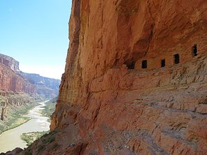
Views that can't be ruined! by chumley  Overview OverviewMost people who visit the granaries come by way of boat. About 52 river miles below Lees Ferry, Nankoweap Creek drains into the Colorado at the largest delta in the entire canyon. The area can be accessed on foot by backpackers by various routes, the easiest route being the unmaintained Nankoweap Trail -- the GCNPs "MOST difficult named trail", the largest rim-to-river elevation gain, and one of the longest distance trails in the entire park. But those arriving by boat have only a short, steep, half-mile hike from the beach up to the granaries. History Despite the geologic mysteries surrounding its creation (or continued existence), archaeological findings show that this alluvial fan delta clearly provided a habitat for historic inhabitants. In 1960, archaeologist Douglas W. Schwartz investigated the area, including the granaries nestled in the cliffs above the river. He found corncobs, a pumpkin shell, and pumpkin seeds inside the granaries. The people who inhabited the delta harvested these and other crops between 1050 and 1150 A.D. Schwartz gathered other evidence of inhabitation in the area, including other ruins, a petroglyph site, and thirty-four pueblo house structures, leading him to conclude as many as 900 people may have lived in the area at that time!
From the main boat beach below Nankoweap Creek, follow the well-traveled route to the north. Here the footing is sandy, weaving in and out of mesquite, tamarisk, bamboo, and other scrub brush. If you are coming from the Upper Nankoweap beach, simply follow a route westward across the rocky sand dune toward the cliffs above. Both routes meet at the base of where the trail turns uphill, directly below the granaries, which are clearly visible above you. From here, there is only low desert scrub amongst the exposed rock slope. (The official GPS route for this hike begins at the main beach and ends at the upper beach showing the route to or from both beach/camp sites). The trail climbs steeply and directly, rarely wasting time with switchbacks. It is rocky, but the footing is generally good, with large slabs placed as sturdy steps along much of the route. As you ascend to over 600 feet above the river, the views downstream are striking. Over 3-miles of the river are visible in a straight line, with the towering walls of the Desert Facade dominating the eastern wall of this lowest stretch of Marble Canyon. The plateau above sits at 6000-feet, 3,200-feet above the river! The top of the trail becomes more unstable, with more loose footing and scree. Many will stop at an excellent flat overlook just below the base of the cliff. Others can continue and follow the path which traverses below the cliff to the north and then switchbacks up the first level and back to the primary granary. Some scrambling is required to get the extra 10-20 feet up to the granary level, and those uncomfortable with heights and exposure may choose to stay just below. From here, excellent photo opportunities exist, and afternoon shade provides a welcome break from the heat. A narrow shelf continues from below the primary granary southward to a secondary enclave for the most adventurous. A third can be found even farther south, this one being a large cavernous opening in the cliff wall and the most prominent feature when seen from the river below. This one, however, requires serious contemplation, with severe exposure, and a 3-foot section of the shelf which is missing and must be traversed very carefully! This third opening features no ancient ruins, so the reward of getting to it may not be worth the risk for most. When you've seen all you want to see, head back down to the beach, watching your step carefully on the steep descent. RESPECT THE RUINS One of the reasons sites like this are so special is because it is fantastic to see something so old remaining in such good condition. Please help keep it that way! Don't touch the ruins. Don't go in the granaries. Don't remove anything you find or see there. Observe, enjoy, take pictures. Hopefully, it will still look the same in another 900 years! Check out the Official Route and Triplogs. Leave No Trace and +Add a Triplog after your hike to support this local community. | |||||||||||||||||||||||||||||||||||||||||||||||||||||||||||||||||||||||||||||||||||||||||||||||||||||||||||||||||||||||||||||||||||||||||||||||||||||||||||||||||||||||||||||||||||||||||||||||