Route Editor

| Guide | ♦ | 1 Triplog | 0 Topics |
details | drive | permit | forecast | route |
stats |
photos | triplog | topics | location |
| 43 | 1 | 0 |
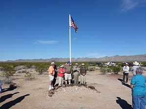
Melting eyeballs since 1943 by kingsnake  History HistoryCamp Bouse was one of 12 camps in the American Army's World War Two Desert Training Center (DTC), or California-Arizona Maneuver Area (CAMA). The DTC triangle stretched from Pomona, CA, northeast to Searchlight, NV, southeast to Hyder, AZ, and back to Pomona. At 18,000 square miles, it was the largest military facility in American history. The DTC was activated in April 1942 and closed in July 1944. The DTC's primary mission was to train American troops to fight in North Africa. Camp Bouse was established in the Butler Valley, east of Bouse, AZ, in September 1943. The location for the top-secret Canal Defense Light (CDL) project was chosen as it was the most remote the Army could find. Even 70+ years later, the site is 20 miles from the nearest paved road.
Warning Things should be left where you see them, not just because Camp Bouse is a historical site, but because there might still be unexploded ordnance ("bombs"), or UXO, about. Don't pick things up, especially metal ones outside the main post area. Overview The Camp Bouse Memorial Park at AZ 72 and Main St. in the middle of the hamlet of Bouse, contains many plaques dedicated to Camp Bouse units. After visiting the park, drop by the Bouse Assay Office a block east on Main St., which doubles as a Camp Bouse museum/souvenir stand. They have many Camp Bouse and World War II artifacts, plus brochures, available. After visiting the park and museum, head out to Camp Bouse, which is a 45-60 minute drive. Hike Being essentially a ghost town, Camp Bouse is not a hike, with a defined route, but rather an exploration. If you go on the narrated Bouse Chamber of Commerce tour the second full weekend in February, you will get a lot more information -- especially from the Camp Bouse veterans that are still with us -- but have less time to explore. But that info will provide the context for future exploration, as there is not a whole lot of Camp Bouse info online. It was, after all, top secret. (So top secret that the soldiers were rarely let off post, and then only if escorted by at least two other soldiers to ensure lips were not loosened.) When you do choose to explore on your own, take a copy of the main post map with you, so you can identify where the remains of the unit areas and facilities are. The main post area is identified as "Camp Bouse" on CalTopo and MyTopo. The entrance from Powerline Rd. is this hike's listed trailhead. (But please park at the indicated parking area, then explore on foot, to preserve any artifacts.) There was only one building on Camp Bouse -- the hospital -- which was otherwise all tents. Stone surfaced and lined walkways were constructed, some of which remain. There was also a round, bermed, boxing arena. Several water facilities are still identifiable. The fence across post is more recent, not the World War II period. There are a few concrete pads. There are historical markers, both signed and constructed of rocks. There is a guest register not far from the chapel; feel free to sign it. Note that there are old firing ranges -- and possible UXO -- at lat/long 34.04793, -113.758519 and lat/long 34.044694, -113.766802 -- northwest of camp, not far from Powerline Rd. You might see some oblong rock piles or oblong holes with rocks scattered around them. Those are the old pit latrines, which were filled in with rocks when Camp Bouse was shut down. Where rocks are scattered it is because scavengers were willing to dig through poo in search of the crate of Colt M1911 0.45 semiautomatic pistols rumored to be buried in one. I'd rather search for the Lost Dutchman. Check out the Official Route and Triplog. Leave No Trace and +Add a Triplog after your walk/tour to support this local community. | ||||||||||||||||||||||||||||||||||||||||||||||||||||||||||||||||||||||||