Route Editor

| Guide | ♦ | 19 Triplogs | 0 Topics |
details | drive | permit | forecast | route |
stats |
photos | triplogs | topics | location |
| 111 | 19 | 0 |
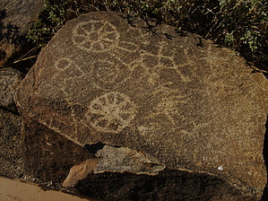
A link to the past. by Jeffshadows  History HistoryThe Tucson Mountain Park area was the site of numerous Hohokam villages and farms from approximately 200 to 1450 AD. As a consequence, the Park now boasts a variety of sites for us to visit which allow us to experience their culture, first-hand. Signal Hill is so named for the series of petroglyph panels that adorn the rocks at its apex. One of the most notable is a large single spiral that faces the summer sun at noon. Some historians believe that the presence of this spiral indicates that the area once housed a reliable spring. Nearby panels include zoomorphs of bighorn sheep, snakes, and what might be a frog. Countless other symbols are also present, many human-like; including a human mirror-image. When the Park was created in 1933 the site was protected. Hike The trail is quite brief and well-maintained. It consists of two minor wash crossings and a series of developed stone steps. The course of the track is wide and sandy. Informational signs are present at various points, and the trail intersects both the Manville and Cactus Wren trails providing possibilities to make longer trips to nearby attractions. Shortly after the second wash crossing, a small informational panel stands just off the trail near where one of the best views of the lower panels can be obtained. The trail makes its final ascent through the basalt boulders near the apex of the hill and ends at a cordoned-off vista with great views of the ranges to the west, and, of course, the petroglyph panels nearby.
Check out the Official Route and Triplogs. Leave No Trace and +Add a Triplog after your hike to support this local community. | |||||||||||||||||||||||||||||||||||||||||||||||||||||||||||||||||||||||||||||||||||||||||||||||||||||||||||||||||||||||||||||||||||||||||||||||||||||||||||||||||||||||||||||||||||||||